Monday, February 29, 2016

TUESDAY SNOW FORECAST

SNOW FORECAST
Rain/snow mix will change to all snow
more quickly across the north end
of our viewing area.

Accumulations in the Toledo Area could reach 4".

Robert Shiels WTOL    @RobertWTOL

ALERT DAY: MARCH COMES IN LIKE A LION

WINTRY WEATHER
A rain/sleet/snow mix at midday
will change to all snow later in the day.
Accumulations of 1-4" are possible,
though it may be difficult to measure.
Any snow is likely to be very slushy at onset.

 6:00 AM
The morning commute should be fine.

4:00 PM 
A wintry mix is likely in the Toledo area.
All rain is likely south of US-6.

6:00 PM 
A changeover to all snow is likely.

SNOW FORECAST 
Snow in the Toledo area may range
from just 1" to as much as 4".
2-5" is possible in southeast Michigan.
Lower amounts are likely to the south.

An update will be issued tonight.

Robert Shiels WTOL    @RobertWTOL

ALERT: Wintry Mess Ahead

The taste of Spring has been sweet, but once again will be interrupted by a return to wintry weather on Tuesday.  Or next ALERT Day will highlight a wintry mix which will arrive Tuesday Afternoon.
ALERT DAY Headlines

It is very likely Tuesday afternoon will feature rain far to the south, Sleet and ice pellets in norther Ohio and snow in southern Michigan. 

Hour By Hour Radar Depiction -- 4 PM Tuesday
 I expect it will all chance over to snow Tuesday evening with a period of snow, possibly steady from 6 PM to Midnight. Expected tweaks to the evolving storm track will influence "WHERE" the heaviest snow is, but a widespread 1 to 3" of snow will be expected with snow gone by daybreak Wednesday morning.

Expected snow by 6 AM Wednesday


~Meteorologist Chris Vickers

Sunday, February 28, 2016

Shorts And Shovels?

Depending on your view -- this has been an easy winter with little snow and cold. Or this winter has been a disappointing one if you're a snow lover. Both groups will have a bit to enjoy about with this forecast: 


60° on Sunday will make this the second straight weekend with a high of 60 in Toledo. But there is a system to watch this week that will quick change us back to a wintry setting. 


A strong piece of energy will come ashore near Vancouver, Canada later today. Over the next 48 hours it crosses the Rockies and Central Plains. 


When the system re-develops in the Great Lakes, northwest Ohio may be in that classic rain/snow mixing ground. This system has the potential to drop several inches of snow and we will be watching closely. 

Saturday, February 27, 2016

Sunday forecast.

HOUR-BY-HOUR FORECAST
Morning:  some sunshine.
Afternoon:  clouding up.
After sunset:  rain showers likely.

SUNDAY  4:00 PM 
Clouding up quickly.

SUNDAY  8:00 PM 
Rain showers likely.

Robert Shiels WTOL    @RobertWTOL

Friday, February 26, 2016

SPRING FEVER!

WEEKEND FORECAST
Saturday:  partly sunny, breezy.
Sunday:  windy, showers late.

Robert Shiels WTOL    @RobertWTOL

Wednesday, February 24, 2016

WEATHER UPDATE 10:00 PM WEDNESDAY

SNOW FORECAST
Snow amounts through noon Thursday.
Light snow will bring 1-3" across the area.

TOLEDO AREA FORECAST 
2-3" of snow possible by 10:00 AM.

THURSDAY FORECAST 
LIght snow in the morning, windy.
Highs mid 30s, winds gusting to 35 mph.

A WARMER WEEKEND 
Spring Fever is back this weekend.
It will be quite windy with highs reaching
near 60 degrees Sunday afternoon!


Robert Shiels WTOL    @RobertWTOL

WEDNESDAY 10:00 PM UPDATE

SNOW FORECAST
Snow amounts through noon Thursday.
Light snow will make for minor accumulations.

TOLEDO AREA FORECAST 
1-2" of snow possible by 10:00 AM.

THURSDAY FORECAST 
LIght snow in the morning, windy.
Highs mid 30s, winds gusting to 35 mph.

A WARMER WEEKEND 
Spring Fever is back this weekend.
It will be quite windy with highs reaching
near 60 degrees Sunday afternoon!

Robert Shiels WTOL    @RobertWTOL

UPDATE: Snow Accumulation

Updated snow accumulation forecast as of 10 AM on Wednesday.  Greatest snow accumulations, possibly in excess of 6" or more will be expected far west and north of Toledo.  
Expected snow Today - Thursday

A cold, windy driving rain will be expected into the afternoon.  Snow remains possible in southern Michigan and far NW Ohio.  All precipitation changes to snow by 11 PM tonight.  
Hour By Hour Forecast -- 4 PM
~Meteorologist Chris Vickers

Tuesday, February 23, 2016

UPDATE: 11PM TUESDAY

RAINY, WINDY AND COLD
Wednesday will be blustery and damp.
Wind chills in the 20s with Northeast winds 15-25g35.

HOUR-BY-HOUR FORECAST 
6:00AM Wednesday
Brief mix possible at onset of precipitation.

Noon Wednesday
Rainy, windy and cold.

6:00PM Wednesday
Rain changing to snow possible
in Hillsdale and Williams counties.

11:00PM Wednesday
Winds shift to North-northwest.
Rain changing to snow in Toledo area.

6:00AM Thursday
Delays possible to start the day.

Noon Thursday
Some lingering snow showers.
Windy and cold.

SNOWFALL FORECAST 
Snow accumulations in the Toledo area
will likely reach 2-3" by Thursday afternoon.

Note:  Meteorological Winter ends next Monday!

Robert Shiels WTOL    @RobertWTOL

Video Forecast - February 23rd, 2016

Rain First, Then Snow

It has been a quiet winter to say the least when you compare it to the past few. Later this week we still stand a chance to see some accumulating snow but our area will likely miss out on the heaviest snow bands. Here is our latest forecast as of NOON on Tuesday. 


Most of the area will see 1-3" of snow through Thursday with far NW Ohio and Hillsdale area perhaps being clipped by that heavier band of snow. 


For many, the worst part of this storm may actually come Wednesday morning with driving wind and sheets of rain falling. 


Please stay tuned to our latest forecast for more information. As always, thank you for trusting our team with important weather updates.

Alert: Updated Snow Accumulation

We will hit the weather Trifecta the next three days...Sun, Rain & Snow.  Here is the simple message that has been highlighted by our Alert Days for Wednesday and Thursday.  

Today: Sunshine & Dry

Wednesday: Soaking Rain & Chilly and Windy

Thursday: Accumulating Snow and Windy

ALERT Day Headlines
Steady rain will greet you out the door in the morning.  Have the umbrella and rain jacket prepared.  Greatest concern for flooding will likely be possible basement flooding in prone area.  
Expected Rainfall Wednesday thru Wednesday Night
Who will need the snow shovel Thursday after this storm is all said and done?  Snow will begin near or just after midnight Thursday morning.  Several hour of steady, slushy snow will occur through the Thursday morning drive.  Much of the area will total 2 to 4" of an accumulation.  The best chance of over 4" of snow will be far west and north of Toledo.  Be alert to very windy conditions Thursday afternoon with northwest winds of 20-30 mph gusting to 40 mph.

Thursday Snow Accumulation

~Meteorologist Chris Vickers

Monday, February 22, 2016

WINTER IS NOT OVER YET!

ALERT DAYS MIDWEEK
Windy, unsettled weather moves in midweek.
Wednesday will be rainy, then Wednesday
night and Thursday may bring some snow!
WINTER SNOW TOTALS 
The snowfall total for the entire winter season
is still only 12", 17" behind a normal pace.
TUESDAY  6:00PM 
A storm developing over the deep south
will bring a risk of severe weather to
parts of LA/MS/AL/FL on Tuesday.
Our local weather will be similar to Monday.
It will be partly sunny, breezy with highs near 40.
WEDNESDAY  8:00AM 
The storm will move north overnight
bringing rain to northwest Ohio early Wed.
WEDNESDAY  6:00PM 
Wednesday will be a rainy, cold and windy day.
Northeast winds will gust to 30-35mph
Highs will be in the upper 30s.
The best chance of snow Wednesday will be in northwest and north central Indiana tracking into central lower Michigan.  Cities likely to be impacted by the snow are South Bend, Jackson and Lansing.  A northeast wind will turn northerly Wednesday night and a changeover to snow is possible in southeast Michigan and northwest Ohio.
Those with travel plans late Wednesday and early Thursday should continue to monitor our First Alert forecasts for updates.  We will provide forecasts of snow amounts Tuesday.
Robert Shiels WTOL    @RobertWTOL

ALERT: Winter Storm...Will It Happen?

We are fine tuning the details on back to back ALERT days on Wednesday and Thursday and more information comes in.  Each day brings different, distinct threats.  Wednesday will bring heavy rain.  Thursday will bring accumulating snow and very gusty winds.  
WTOL ALERT Days
Heavy rainfall may begin by midday on Wednesday.  Rounds of rain will bring 1 to 2" of rain through Wednesday night.  Localized minor flooding may be possible. Pay especially close attention to basement flooding in prone areas. 
Projected Rainfall Wednesday

Will we see a Winter Storm? Overnight Wednesday and into Thursday morning the rain will change over to snow. (Most likely before daybreak)  Uncertainty in snow accumulations still exists!  However, several inches of accumulating snow is possible on Thursday along with gusty winds.  The zone of heaviest snow -- 6" or more -- will likely be far north and west of Toledo and may miss much of the viewing area.  Still with that said, several inches of an accumulation will still be possible.  This could still be the largest winter storm of the otherwise lackluster winter season.  (Greatest 1 day snowfall was November 21st with 3.5")
    
Possible Snowfall Thursday

Additional Technical Weather Information

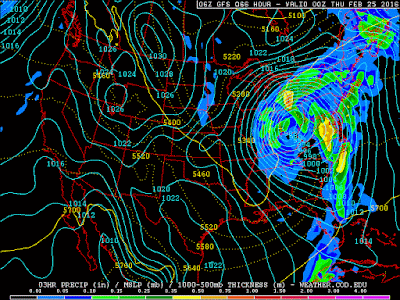
There has been a slight dip south and east in latest model runs which brings colder air into play a bit earlier than Sunday's thinking.  If this holds, it may warrant higher snow totals from this storm.  This storm system is also rapidly strengthening as it tracks across southern Ohio.  A 988 mb low will deepen to 980 mb by Thursday evening.  This will generate quite a windy Thursday afternoon.  Don't discount the very large impact strong and gusty winds may play into Thursday as well.
GFS Model Prog for Wednesday Evening
~Meteorologist Chris Vickers

Sunday, February 21, 2016

UPDATE: Mid-Week Storm

It has now become clear that our mid-week storm is not likely to be a major snow producer for us, but instead will drop heavy rain Wednesday.

Early this weekend we mentioned two potential storm tracks. One warm, one cold. The warmer path has won out:


Monday and Tuesday will be quiet weather days but Wednesday will be close to, if not a complete washout. Over 1" of rain is likely to fall Wednesday.

River flooding is possible but not likely to be as severe as the past few years with minimal ice/snowpack and a non-frozen ground.


As our system lifts into Ontario, snowfall may fill in on the backside of this system but totals are likely in the 1-3" range, if even that high.

Stay tuned for more forecast updates as we get closer.