Monday, December 23, 2013

December Flooding

Widespread flooding will continue on area rivers and streams with many locations remaining under standing water.  Just how much rain fell this past weekend?  


This lined up very close to the forecast that we consistently called for Thursday and Friday of last week.  Here were those projections:


Moderate to major flooding will continue on many area rivers, with significant improvements the next 24 hours.  Here are a few rivers with the latest crest information.


Take a look at what the city of Findlay would look like from above at the crest of the flooding this morning at just shy of 15.5'. 


Many communities near rivers will continue to see flooded roadways.  UNDER NO CIRCUMSTANCE, DO NOT EVER DRIVE THROUGH A FLOODED ROAD.  You man never know the true depth of the water, if the road is washed out or the strength of the current.  Flowing water of 12" or less can sweep you off your feet and sweep away your vehicle.  

~ Meteorologist Chris Vickers

Wednesday, December 18, 2013

Weekend Storm -- Significant Rain Maker

The track of a weekend storm still looks to target the area late Saturday and through the day on Sunday. This storm has been on our radar since last weekend, and despite varying model differences, our forecast has remained consistent calling for mainly widespread rain into the area.  Unfortunately, even with the big snowpack now, the chance of a white Christmas next week looks very low.  Here is the current picture and my take on how this storm will evolve.  


Upper level Jetstream energy over the Pacific Ocean will parallel the west coast of the United the next 24 to 36 hours.  From there a deep trough will sweep into the Chihuahuan Desert in Mexico.  Into this weekend a powerful storm will evolve, drawing significant moisture from the Gulf of Mexico up into the Great Lakes region.  

Despite a stray radical early model projection of widespread snow, all other models have remained consistent on this being mainly a rain event.  Our forecast has mirrored that and remained consistent calling for widespread and potentially heavy rain.  It's the task of a meteorologist to sift through and analyze immense amounts of data to determine the most realistic outcome based on all data available.  It's important to understand any computer model projection does not equal a sound and well reasoned weather forecast!  

A heavy rain event, with potentially localized flooding will be the main concern this weekend.  I expect light rain showers to begin on Friday with less than 0.25" of rain possible.  After a break in rain early Saturday, steady and possibly heavy rain Saturday night and into the day Sunday is expected.  This may bring 1.0" to 1.5" of rain for rainfall totals during the weekend up to 2".  This combined with current snowpack and a frozen ground may lead to localized flooding.  Here is a projected model ensemble (combination of many models) for anticipated precipitation through the weekend from the WPC (Weather Prediction Center).  


Wintry weather is not completely out of the mix here, I do anticipate late on Sunday that we will turn cold enough for a few hours of snow to mix in.  Best chance of an accumulation would be northwest of Toledo.  Stay tuned for additional updates!

~Meteorologist Chris Vickers
Twitter: @ChrisWTOL
  

Monday, December 16, 2013

Alberta Clipper -- More Snow

Alright folks another round of wintry weather headed out way this evening via an Alberta Clipper.  These systems are notorious for being quick hitting, light snow producers.  Here is the latest location of the Clipper which will be directly targeting the area after dark tonight


This will be a steady, quick and hard hitting "light and fluffy" snow that will quickly amount to accumulations in the 1 to 2" range with an additional 1" possible on Tuesday afternoon.  Total accumulations will be around 3" by tomorrow afternoon.  It will become quite windy Tuesday afternoon and evening with widespread blowing and drifting snow.  This will likely create very hazardous travel conditions.


Thursday, December 12, 2013

Ice Starting to Form on Lake Erie

The recent cold snap has allowed the lake temperature to rapidly drop in the shallow western basin. Mid-December is typically when we do see the first formation of ice. Forecasts have it forming rather quickly with the cold overnight lows expected the next week or two.


Above is the ice coverage map and a view from the Toledo Harbor

Tuesday, November 19, 2013

November Tornado Outbreak


Great Lakes Severe Weather Outbreak
November 17th, 2013

November tornado outbreaks are rare, but very dangerous.  They are certainly not an unheard of occurrence.  Often the atmospheric dynamics during the seasonal flux of Autumn can create favorable environments for severe thunderstorms and tornadoes. There have been two instances where the Storm Prediction Center has issued a High Risk in the month of November.  


Many may remember November 10th, 2002 (pictured to the left above) which included widespread and significant torndoes in Northwest Ohio -- Including the F4 tornado that demolished parts of Van Wert, Ohio. That makes this most recent November outbreak the second one in just over a decade.


  Sunday, November 2013 was the third time the Storm Prediction Center has issud a High risk in November. It was a 24 hour period that sent a wave of severe storms and tornadoes racing across the Great Lakes.  Here is time lapse of the watches and warnings issued in less than 24 hours from Illinois through Ohio and eventually racing off the East Coast.  The red indicates tornado warnings and the orange indicates severe thunderstorm warnings. 


Here is the reported instances of severe weather from Sunday


There were a total of 5 tornadoes in Ohio with 4 of them occurring in northwest Ohio.  Here are the details of the tornadoes that impacted the local area. 


EF-2 TORNADO /PAULDING COUNTY OH AND PUTNAM COUNTY OH/...  PATH LENGTH:  8 MILES 
MAXIMUM ESTIMATED WIND SPEED:  130 MPH 
MAXIMUM ESTIMATED PATH WIDTH:  440 YARDS 
START TIME:  ESTIMATED AROUND 451 PM EST 
END TIME:  ESTIMATED AROUND 459 PM EST 
LOCATION:  TOUCHDOWN OCCURRED ABOUT 0.25 MILES SOUTH OF THE INTERSECTION OF ROUTE 66 AND 
COUNTY LINE ROAD IN SOUTHEAST PAULDING COUNTY AND LIFTED ABOUT 5 MILES NORTHEAST OF 
CLOVERDALE IN WEST CENTRAL PUTNAM COUNTY.


EF-2 TORNADO CONFIRMED IN WOOD AND LUCAS COUNTIES...

LOCATION...LIME CITY ROAD & US ROUTE 20 IN PERRYSBURG OHIO
(WOOD COUNTY) TO CORDUROY ROAD & WYNN ROAD IN OREGON OHIO
(LUCAS COUNTY)
DATE...NOVEMBER 17, 2013
ESTIMATED TIME...535 PM EST TO 555 PM EST
MAXIMUM EF-SCALE RATING...EF-2
ESTIMATED MAXIMUM WIND SPEED...120 MPH TO 125 MPH
MAXIMUM PATH WIDTH...150 TO 200 YARDS WIDE
PATH LENGTH...APPROXIMATELY 12 MILES


THE TORNADO FORMED NEAR LIME CITY ROAD AND US ROUTE 20 IN
PERRYSBURG. THE TORNADO REACHED EF-2 STRENGTH NEAR OREGON ROAD
AND ROUTE 795 NEAR PERRYSBURG. IT THEN CONTINUED MOVING NORTHEAST
AT MOSTLY EF-1 OR EF-0 STRENGTH AND THEN REACHING EF-2 STRENGTH
AGAIN IN THE CITY OF OREGON WHERE SEVERAL HOMES WERE DESTROYED.


EF-1 TORNADO CONFIRMED IN WOOD COUNTY...

LOCATION...THE TORNADO TOUCHED DOWN ON THE EAST SIDE OF JERRY CITY
NEAR MAIN STREET AND HUFFMAN ROAD AND LIFTED ABOUT 1 MILE EAST ALONG
JERRY CITY ROAD.
DATE...NOVEMBER 17, 2013
ESTIMATED TIME...535 PM EST TO 540 PM EST
MAXIMUM EF-SCALE RATING...EF-1
ESTIMATED MAXIMUM WIND SPEED...105 MPH TO 110 MPH
MAXIMUM PATH WIDTH...75 TO 100 YARDS WIDE
PATH LENGTH...APPROXIMATELY 1 MILES
NATIONAL WEATHER SERVICE CLEVELAND OHIO

...EF-1 TORNADO CONFIRMED IN OTTAWA COUNTY...

LOCATION...3 MILES EAST OF ELMORE IN OTTAWA COUNTY
DATE...NOVEMBER 17, 2013
ESTIMATED TIME...600 PM EST
MAXIMUM EF-SCALE RATING...EF-1
ESTIMATED MAXIMUM WIND SPEED...95 MPH
MAXIMUM PATH WIDTH...50 TO 75 YARDS WIDE
PATH LENGTH...APPROXIMATELY THREE QUARTERS OF A MILE


THE TORNADO TOUCHED DOWN NEAR YEASTING ROAD AND STATE ROUTE 590 AND
MOVED NORTHEAST ABOUT THREE QUARTERS OF A MILE BEFORE DISSIPATING.

This was the largest and most significant outbreak of tornadoes in the areas since the June 5th, 2010 Lake Twp and Millbury tornadoes.  Fortunately this time around, despite total tornado tracks of nearly 22 miles there were ZERO fatalities and only minor injuries.  

~Meteorologist Chris Vickers


Saturday, November 9, 2013

StormTrack Spotters Post -- Severe Weather Climatology

This post is the first in a series over the coming weeks and months to help prepare our group of 'StormTrack Spotters' how to track and report severe weather in Northwest Ohio and Southeast Michigan. These spotters directly send us pictures and any weather reports. If you or someone you know would be interested, check out the bottom of this post for more information!


Severe Weather Climatology
Before we can dive into individual storms and how the atmosphere works, we must understand a broad picture about severe weather. How often does it really happen? In northern Ohio and southern Michigan we are no strangers to severe weather. But, we are also far from the first place you likely think of for damaging and destructive storms.

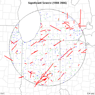
Let's break down the last 70 years or so. Quality reporting dramatically increased during the 1950's and beyond. That's why many of the maps you will see start mid-way through the 20th century. Below are two maps. The first are severe weather reports over the past 30 years or so. You'll notice no county or area is spared. Severe weather can happen anywhere. There are no voids due to 'valleys', rivers, cities, etc.


This second map is of 'significant severe weather'. That is a strong/violent tornado, large hail or very strong straight line winds. As you would expect, the map is not as covered as the first. While severe weather can happen anywhere in our area, there are a few patterns to be seen. The most notable being tornado paths. Most either go from the southwest to the northeast, or from the northwest to the southeast. If you have followed severe weather, you'll know that most tornadoes do go from SW to NE. But many times in our area, summertime thunderstorm travel from the NW to the SE. It is common. Don't be caught off guard by it. 

So how 'much' severe weather do we see each year? 

Tornadoes:
Typically NW Ohio/SE Michigan averages around 4 tornadoes per year and a strong tornado around every 10-15 years. Not very often compared to some parts of the country, but often enough for me! 

Straight line winds:
This tends to be the most widespread of our severe weather threats each year. Winds can form during strong thunderstorms in the spring/summer, deep low pressure system in the autumn, and blizzards in the winter. The most damaging straight line threat comes from a thunderstorm complex called a 'derecho' The southern Great Lakes averages one of the storms per year. Learn more: http://www.spc.noaa.gov/misc/AbtDerechos/derechofacts.htm


When does severe weather tend to strike?
If you have lived in this area long enough, you know that thunderstorms can come along at anytime of the year. Our heightened months tend to be June and July. This is when the jet stream is retreating north into Canada and instability/moisture from the Gulf of Mexico has returned. 

A 'second season' of severe weather also tends to occur in October/November. This is due to the same process as above, but reversed. The jet stream is moving back south with some instability still possible. 

Remember, these are only the peak months. Some of our largest severe weather outbreaks have occurred during other months. Take for example the Palm Sunday Tornado outbreak of 1965. Never let your guard down, simply because of what the calendar says.  

What to learn more? Check out these links: 


Want to become a 'StormTrack Spotter'!?
You don't have to know much or anything about storms to join. We just want individuals who will participate by safely snapping photos and provide quality information. Check out this link for more info on signing up: http://tnnstormtrack.blogspot.com/2013/06/stormtrack-weather-spotter-sign-up.html

Wednesday, November 6, 2013

This Date in 1871

Did you know that Toledo was one of the original weather reporting cities for the Weather Bureau (You know it as the U.S. National Weather Service) in the late 1800's? At the time, Toledo was an important port city on the Great Lakes. 
 
Today we have the luxury of satellites, radars and advanced computer equipment to help in forecasting. But back in the 1800's there wasn't as much technology. In fact typically only once-a-day measurements of temperature, wind direction and barometric pressure. 


Grant was president when the Weather Bureau was created
In 1869, routine observations via telegraph were being made daily in the United States. These reports were then charting, allowing for the first time an attempt to forecast the weather. This was especially important for maritime and agriculture interests at the time. 

Just for fun, we went back into the records and found today's weather in 1871. 

November 6, 1971
Notice how the western United States does not have many stations. Not many people lived there and many territories were not even states yet. Really the only reporting stations are where the transcontinental railroad had been build and near the coast. 

Tuesday, November 5, 2013

100th Anniversary of the 'White Hurricane'

Think of a ship sinking during bad weather in the Great Lakes and the name that comes to mind is likely the 'Edmund Fitzgerald'. But 100 years ago this weekend a storm battered and bruised the fresh water shipping industry like never before...or since.

The Henry B. Smith was sunk on Lake Superior during the storm

It was dubbed the 'White Hurricane' and the 'Freshwater Fury' after the storm sunk 12 ships and grounded at least another 30 more on the Great Lakes. This was a time when meteorology was more of a 'wait and react' business compared to the days ahead forecasting provided today. Ships were also build using materials that struggled to fight against the bitter cold and punishing waves.

Location of the shipwrecks from the storm

The system was actually a combination of two weather makers. A large trough driving through the heart of the country picked up a low pressure center moving up the east coast. The two combined to 'bomb' a low through the Great Lakes. The intense pressure gradient created winds 60-80 mph.

While winds were a big impact to the shipping industry, snow was another big effect from the storm. Cleveland reported over 17" of snow in a 24 hour period. Smashing the 24-hour record. Lake effect snow was reported from Northern Michigan to Buffalo.


November 9th, 1913 morning weather map


The National Weather Service has provided a ton of information on the storm. Check it out here

Tuesday, October 29, 2013

Hurricane Sandy -- One Year Ago

Hurricane Sandy churned up an angry Atlantic Ocean as it encountered the warmer Gulf Stream current and re-intensified once again off the coast of a mid Atlantic with sustained winds to 90 mph and an astounding central pressure of 943 mb.  Within 24 hours Sandy would drive a massive wall of water -- a storm surge- into the Mid Atlantic and New England States. The official landfall coincided with a post tropical transition which continued to blast the East Coast with winds 60-90 mph, heavy rain and severe coastal flooding. 


Here is more graphical information from the National Hurricane Center:

Here is an excerpt from the 11 AM NHC Discussion on the 29th of October contining to detail the life threatening nature of this storm:

WIND...TROPICAL STORM CONDITIONS...OR GALE-FORCE WINDS...ARE ALREADY
OCCURRING OVER PORTIONS OF THE MID-ATLANTIC STATES FROM NORTH
CAROLINA NORTHWARD TO LONG ISLAND. GALE-FORCE WINDS ARE EXPECTED TO
CONTINUE TO SPREAD OVER OTHER PORTIONS OF THE MID-ATLANTIC
COAST...NEW YORK CITY...AND SOUTHERN NEW ENGLAND TODAY.
HURRICANE-FORCE WINDS COULD REACH THE MID-ATLANTIC STATES...
INCLUDING NEW YORK CITY AND LONG ISLAND...BY THIS EVENING. WINDS
AFFECTING THE UPPER FLOORS OF HIGH-RISE BUILDINGS WILL BE
SIGNIFICANTLY STRONGER THAN THOSE NEAR GROUND LEVEL.

STORM SURGE...THE COMBINATION OF AN EXTREMELY DANGEROUS STORM SURGE
AND THE TIDE WILL CAUSE NORMALLY DRY AREAS NEAR THE COAST TO BE
FLOODED BY RISING WATERS. THE WATER COULD REACH THE FOLLOWING
DEPTHS ABOVE GROUND IF THE PEAK SURGE OCCURS AT THE TIME OF HIGH
TIDE...

NC NORTH OF SURF CITY INCLUDING PAMLICO/ALBEMARLE SOUNDS...4 TO 6 FT
SE VA AND DELMARVA INCLUDING LOWER CHESAPEAKE BAY...2 TO 4 FT
UPPER AND MIDDLE CHESAPEAKE BAY...1 TO 3 FT
LONG ISLAND SOUND...RARITAN BAY...AND NEW YORK HARBOR...6 TO 11 FT
ELSEWHERE FROM OCEAN CITY MD TO THE CT/RI BORDER...4 TO 8 FT
CT/RI BORDER TO THE SOUTH SHORE OF CAPE COD INCLUDING BUZZARDS
BAY AND NARRAGANSETT BAY...3 TO 6 FT
CAPE COD TO THE MA/NH BORDER INCLUDING CAPE COD BAY...2 TO 4 FT
MA/NH BORDER TO THE U.S./CANADA BORDER...1 TO 3 FT

SURGE-RELATED FLOODING DEPENDS ON THE RELATIVE TIMING OF THE SURGE
AND THE TIDAL CYCLE...AND CAN VARY GREATLY OVER SHORT DISTANCES.
GIVEN THE LARGE WIND FIELD ASSOCIATED WITH SANDY...ELEVATED WATER
LEVELS COULD SPAN MULTIPLE TIDE CYCLES RESULTING IN REPEATED AND
EXTENDED PERIODS OF COASTAL AND BAYSIDE FLOODING.  IN ADDITION...
ELEVATED WATERS COULD OCCUR FAR REMOVED FROM THE CENTER OF SANDY.
FURTHERMORE...THESE CONDITIONS WILL OCCUR REGARDLESS OF WHETHER
SANDY IS A TROPICAL OR POST-TROPICAL CYCLONE.  FOR INFORMATION
SPECIFIC TO YOUR AREA...PLEASE SEE PRODUCTS ISSUED BY YOUR LOCAL
NATIONAL WEATHER SERVICE OFFICE.

RAINFALL...RAINFALL TOTALS OF 3 TO 6 INCHES ARE EXPECTED OVER FAR
NORTHEASTERN NORTH CAROLINA WITH ISOLATED MAXIMUM TOTALS OF 8
INCHES POSSIBLE. RAINFALL AMOUNTS OF 4 TO 8 INCHES ARE EXPECTED
OVER PORTIONS OF THE MID ATLANTIC STATES...INCLUDING THE DELMARVA
PENINSULA...WITH ISOLATED MAXIMUM AMOUNTS OF 12 INCHES POSSIBLE.
RAINFALL AMOUNTS OF 1 TO 3 INCHES WITH ISOLATED MAXIMUM AMOUNTS OF
5 INCHES ARE POSSIBLE FROM THE SOUTHERN TIER OF NEW YORK STATE
NORTHEASTWARD THROUGH NEW ENGLAND.

SNOWFALL..SNOW ACCUMULATIONS OF 2 TO 3 FEET ARE EXPECTED IN THE
MOUNTAINS OF WEST VIRGINIA WITH LOCALLY HIGHER TOTALS TODAY THROUGH
WEDNESDAY. SNOWFALL OF 1 TO 2 FEET IS EXPECTED IN THE MOUNTAINS OF
SOUTHWESTERN VIRGINIA TO THE KENTUCKY BORDER...WITH 12 TO 18 INCHES
OF SNOW EXPECTED IN THE MOUNTAINS NEAR THE NORTH CAROLINA/TENNESSEE
BORDER AND IN THE MOUNTAINS OF WESTERN MARYLAND.

SURF...DANGEROUS SURF CONDITIONS WILL CONTINUE FROM FLORIDA THROUGH
NEW ENGLAND FOR THE NEXT COUPLE OF DAYS.

Monday, October 21, 2013

Morning Contrails

Do you ever look up to the skies a see the contrails left behind by jetliners? It is a sign that the upper levels of the atmosphere is very cold. This morning the contrails were so vibrant we could actually see them from outer space! Here is the early morning satellite shot:

Thursday, October 10, 2013

So Far, No Frost

By this time of year, Toledo should have typically seen at least one frosty morning. On a 30 year climatological average, October 6th is the date that this area sees the first frost of the year. 

First Frost/Freeze Data; NWS
Frost forms under the same circumstances as dew-- only the air is near or below freezing. Frost can actually occur under slightly warmer conditions than a hard freeze: 36° or cooler. With overnight lows forecast to stay in the 40s and 50s over the next week or so, it'll be well into the month of October before a true frost develops. 


A freeze looks just as unlikely. At 32° or cooler, a hard freeze can kill vegetation and growth left over from the growing months. The average first freeze date is October 18th. Considering the coolest overnight low we've experienced all year is the 38° F night we had from October 7-8th, a significant change in the weather pattern needs to take place before we're in frost or freeze territory.

With the latest freeze on record falling on November 15th, I can reassure you that we aren't about to break any records, but going this long into the month of October without frost or freeze is quite the accomplishment. 

Thursday, October 3, 2013

A Lesson on Fog


Whether it's a cancellation, a delay, or botched travel plans, fog can cause all kinds of issues for everyone. 
This week has been one of the foggiest of 2013 so far! But why?


There are a few different types of fog, each with different properties and catalysts. 
Radiation
Advection
Frontal
These are just a few that we deal with on a seasonal basis here in Northwest Ohio. 

Radiation fog may be considered the most common. 
Radiation Fog; Picture Courtesy crh.noaa.gov/
This type of fog typically forms at night or just before the sun comes up when conditions are nearly calm and skies are clear. Everyday, due to something called diurnal heating, warmth is absorbed by the earth's surface from the sun. 

Clear skies at night allow the surface temperature to cool down at a faster rate overnight, so when there aren't any clouds to act as a 'blanket' over the surface, warmth collected through the day is lost more rapidly in the evening.

Humidity levels reach 100%, and POOF: fog. 

That's also why recent rains typically cause fog by the next morning. Higher dew points allow the atmosphere to reach saturation quicker, leading to the development of these pesky low level clouds. 

Advection fog looks like radiation fog, but is caused by warm air moving over cold surfaces.
Advection Fog; Picture Courtesy crh.noaa.gov/

Warm air moving into an area can cause rising motion. Air that rises also reaches its saturation point sooner, causing fog to develop. This is a common occurrence over large bodies of water. Lake Erie, for example, will not 'radiate' heat at the same rate as the surrounding lake shores, thus the surface of the water is cooler. Advection fog forms when warm air drifts over that cold surface and water molecules condense out of the air, creating clouds. 

Finally, Frontal fog. 
Steam Fog; Picture Courtesy crh.noaa.gov/

This type of fog forms when a cooler, but drier layer of air, is brought to saturation through evaporation. This could be from rain drops falling into cool, dry air, or from evaporation coming off the surface of a lake or other body of water (also known as steam fog).

Now, in a situation like this week, school delays (and in some extreme cases, closings) are direct results of a foggy morning. So we'll look for these many factors to help forecast the arrival or development of early fog. 

Once it's developed, we'll often say that the sun will 'burn off' the early morning fog.
I promise, there is no fire involved!
It simply means that the sun's heat will help evaporate the moisture that is keeping the air saturated, and as conditions dry out, the fog lifts or dissolves. 

Friday, September 27, 2013

Race for the Cure, Komen NW Ohio: A History of Race Weather


As this year's inaugural Findlay Race for the Cure and the 20th Annual Toledo Race for the Cure approach this weekend, all eyes are on the sky. 

Will the weather hold out?
Will the rain arrive too soon?
Will racers need hand warmers or portable fans? 

Before answering those questions, lets take a look back at the past 5 years of race weather. 


September 28, 2008: 15th Annual Race for the Cure, Toledo
Conditions: Dry
Race Temp: 55°-60°
Daily High: 78°
Winds: N ~5mph

September 27, 2009: 16th Annual Race for the Cure, Toledo
Conditions: Dry
Race Temp: 57°-62°
Daily High: 72°
Winds: SW ~8mph

September 26, 2010: 17th Annual Race for the Cure, Toledo
Conditions: Dry
Race Temp: 54°-59°
Daily High: 66°
Winds: N ~7mph
**Temps were in the 90s just 2-3 days prior to the race**

September 25, 2011: 18th Annual Race for the Cure, Toledo
Conditions: Light Rain, 0.04''
Race Temp: 48°-53°
Daily High: 76°
Winds: S ~4mph

September 30, 2012: 15th Annual Race for the Cure, Toledo
Conditions: Dry
Race Temp: 44°-49°
Daily High: 65°
Winds: NE ~4mph

2012 was the coldest race in the past 5 years. Temps started off in the middle 40s, and barely grazed 50° by the time the final 5K runners were finishing. But, into the afternoon, a nice dry and sunny day unfolded. 

There is also only ONE year on record in the past 5 that yielded any rain. 2011 brought less than on tenth of an inch of rain, and as I recall, the skies opened up just before the race, and the sun came out. It was so symbolic.

Now, as we prepare for two races this year, we need not only one perfect weather day, but two! Back-to-back.

FINDLAY RACE FORECAST: 
Conditions: Dry, Sunny
Race Temp: 49°-54°
Daily High: 79°
Winds: SE 5-10mph

A cool start for runners, survivors and supporters. Temps will warm into the low/middle 50s through the course of the race. The sun will come out to meet racers early, and keep conditions comfortable. 

TOLEDO RACE FORECAST:
Conditions: Partly to Mostly Cloudy, PM Light Rain
Race Temp: 56°-61°
Daily High: 71°
Winds: WSW 5-15mph

A bit more of a breeze picking up as a cold front approaches the race site Sunday morning. The starting line will be dry, but the finish line may have a few sprinkles into the late morning hours. Otherwise, mild, with temps rising into the low 60s by the time the racers cross the finish line. 

Weekend Forecast, 9/28-9/29/13


Thursday, September 26, 2013

Fall Color Outlook

It is a chemical process that begins to trickle to a halt as Autumn begins...shorter daylight and cool and crisp nights begin to halt the production of chlorophyll within the leaves of trees.  The lack of chlorophyll is directly due to less sunlight from the now distant long summer days.  The process of HOW the leaves change colors is science that happens every year, but there are many meteorological (weather) factors that influence just how vibrant the fall colors will be during the season. 


Here is what I expect this fall season of colors to look like. Many of the conditions for the fall color season have already been determined based directly on the recent summer weather.  Summer was ideal, with cooler than normal weather and above average precipitation.  Here are the results:

Temperatures
June: 69.1° (-0.4)
July: 72.2° (-1.3°)
August: 70.1° (-1.4°)

Average Temp: -1.03° Below Normal


Precipitation
June: 6.35" (2.78")
July: 3.94" (0.71")
August: 2.00" (-1.15")

Precipitation: +2.34"

Overall, summer was COOLER than normal and WETTER than normal, although most of the surplus of rain came through early June and July with a dry end to the summer during August.  Despite that adequate precipitation overall and the lack of extreme summer heat put the trees in great health for the change of colors.  This is in stark contrast to last summer where record heat, a searing drought and scorching temperatures put significant "stress" on the trees throughout the entire summer.  This lead to a relative dull and lackluster appearance of the fall colors in 2012. 

We are in great shape now entering into fall, but going forward conditions must remain right for the fall colors to flourish.  Ideal conditions would include lots of sunny days, with regular intervals of rain (once or twice a week) and clear cool nights.  It is ideal to keep sufficient deep sub soil moisture with regular rain.  The clear cool nights help to gradually slow the earlier mentioned chloroplyll production which produces the "green" color of the leaves during the summer.  Without the chlorophyll, the true pigments and colors (yellow, orange, red, brown, etc) show through brightly.  It is also necessary to avoid an early season deep freeze.  A deep freeze before the peak of the fall color season could quickly damage leaves resulting in an abrupt transition to more dull brown colors.

FALL FORECAST:


The typical peak of fall colors in this area is the middle of October.  I expect vibrant colors this fall season.  Possibly the best in several years, if we can maintain regular rainfall.  It is slightly less than ideal that September is below average for precipitation so far at 1.67" (-0.67") if this continues it may somewhat limit the peak colors.  I do expect fall colors to peak the week of October 13th through the 20th.  It would likely be on the earlier side of that timeframe across southern Michigan and toward the end of that week (October 17th -20th) in Ohio.  Enjoy the beautiful fall weather and thank the great summer weather we had for the great fall colors ahead!   

Wednesday, September 25, 2013

Orion & A Spectacular Sunrise

Check out the constellation Orion this morning followed by a great early fall sunrise in Put-In-Bay!


For more information about Orion, one of the most recognizable constellations, take a look at this:
http://www.space.com/16659-constellation-orion.html

Wednesday, September 18, 2013

Full Harvest Moon -- Hello Fall!

It is the tell tale sign that the warm, sultry summer days are numbered and the crisp smell of Autumn is back -- The Full Harvest Moon. 


Tonight is the full moon -- the nicknamed is based on folklore and rich history of the Native Americans and the timing of their corn harvest.  The benefit of the large, bright full moon allowed harvesting to last into the after dark hours simply by the bright light of the moon.  Tonight may be hit or miss on viewing the moon as clouds increase ahead of the next chance of rain pushing into the area for the end of the work week.  Officially, the Harvest Moon is the closest full moon to the Autumnal Equinox which is this Sunday, September 22nd at 4:44 PM.  Bye bye Summer, Hello Fall!

Wednesday, September 11, 2013

Nearly Record Setting Hurricane Humberto

After a quiet 2013 Hurricane season (so far), Hurricane Humberto has entered the scene. Nearly breaking Hurricane Gustav's record (in 2002), Humberto is the second latest FIRST hurricane of the season on record. 

Typically a hurricane forms well before the second week of September, making Humberto remarkable for two reasons:

1. It is a late forming hurricane
2. It is the first official hurricane to form in the Atlantic for the 2013 season.

Humberto became a hurricane officially at 5am, 9/11/13, with sustained winds at 80mph and gusts up to 98mph. It has Category 1 status as of 11am Wednesday.


Humberto's projected path is going to take it for a spin around the Atlantic, making a left hand turn before falling apart, and being downgraded-- likely Thursday or Friday.


While Humberto poses no threat to land (or the US for that matter), it could be the start of a very active pattern in the Atlantic. After Hurricane Gustav formed late in the season in 2002, 3 additional hurricanes formed that year, two of which reached major status. 


Thursday, September 5, 2013

2013 Hurricane Season So Far

Due to the warmer water temperatures towards the end of summer, hurricane season typically hits its peak right around the end of August and into the beginning of September. Storms are provided with ample energy, and development is encouraged by the moist air and favorable wind patterns.

Hurricane season in the Atlantic runs from June 1 to November 30.

Up until September 5th
, only a half dozen Tropical Storms have been named, none of which have reached hurricane criteria for the 2013 season. According to the National Hurricane Center, the season is still on track, and with a little less than three months to go, plenty could still happen. 

Tropical Depression (as of 11am Thursday, Sept 5) Gabrielle, is the seventh named storm of the season. 

As a Tropical Storm, with sustained winds at 40mph, Gabrielle is expected to weaken and make a right-hand turn back into the Atlantic. (NHC)
While Gabrielle has not (and will not) affected the US coast, areas of Puerto Rico and the Dominican Republic are expected to receive an estimated 3-6'' of rain from the storm. TD Gabrielle formed about 70 miles south of Puerto Rico on September 4th, and was briefly upgraded to a Tropical Storm before being downgraded once again, back to a Tropical Depression.


As a Tropical Depression, Gabrielle has sustained winds of 35mph. (NHC)
Gabrielle suffered from too-dry air and an unfavorable wind pattern, so the storm was unable to maintain Tropical Storm force winds (39+mph) and failed to organize.

NOAA's GOES-East satellite captured an image of Gabrielle at 7:32 a.m. EDT on Sept. 5, 2013. The storm had Tropical Storm force winds at the time.
(
NASA GOES Project)

The 2013 season began in early June with Andrea, the first (and only storm) to make landfall on the United States coastline. Here is the rest of this year's list:
ANDREA
BARRY
CHANTAL
DORIAN
ERIN
FERNAND
 Even without a major storm so far this season, the most important fact to remember, is that hurricanes can be devastating, no matter what time of the season they form... (See HURRICANE SANDY: Oct 22-31, 2012)

Thursday, August 29, 2013

New Study Names 3 Major Ohio Cities 'Safest from Natural Disasters'

A new study released by property & real-estate giant, Trulia, claims to provide homeowners with the inside scoop on Mother Nature's fury.

Stormy Weather over Put-In-Bay, OH: Summer 2013

Based on information and data collected from the National Oceanic and Atmospheric Administration (NOAA), US Forest Service, and FEMA's National Flood Insurance Program, the study takes into account neighborhood information and a history of weather violence.


The result? A list of the top ten cities least likely to be impacted by flooding, earthquakes, hurricanes, tornadoes or wildfires.

Ohio contains three of the ten cities on that list. 


Here is the list:

1. Syracuse, NY

2. Cleveland, OH

3. Akron, OH

4. Buffalo, NY

5. Bethesda-Rockville-Frederick, MD

6. Dayton, OH

7. Allentown, PA

8. Chicago, IL

9. Denver, CO

10. Warren-Troy-Farmington Hills, MI


Does this mean, meteorologically speaking, there is a smaller risk of death or destruction in Ohio based on geographical location? Perhaps. But a study looking at the broad risk of multiple weather phenomenon without a focus on the severity of the existing climatological data seems to lack, in my book. 

Tornadoes are on the list of 'least risk' for this study, however in 1974, a tornado in Xenia, OH caused 32 fatalities as a part of a 12-tornado outbreak in a less than 24-hour period of time. 

Xenia is located just 15 miles East of Dayton, OH. 


Xenia, OH, 1974 tornado outbreak


The Xenia tornado was rated an F-5, and the damage done was estimated at $100 Million (in 1974, not adjusted for inflation).

Case in point: The study shows no research considering the impact of winter weather, blizzards or Lake Effect snow. So since many of these cities on the list are located in the Great Lakes region, researchers should be careful to say that the weather here doesn't have a big impact.

http://www.cbsnews.com/8334-505145_162-57599608/top-10-safest-u.s-cities-from-natural-disasters/


Wednesday, August 28, 2013

8 Years Later: Katrina Aftermath

On this date, 8 years ago, Hurricane Katrina slammed into the Gulf Coast, tearing a path through cities and homes, killing 1,577 in the state of Louisiana (NOAA). 1,833 total fatalities were reported.

Hurricane Katrina, 2005

When the storm raged inland from the Atlantic, it reached Category 5 Hurricane strength, with winds up to 174mph. The central pressure of the storm dropped to an astonishing 902mb, as it developed over the course of 8 days in late August.

No storm since the 2005 disaster has come close in comparison to Hurricane Katrina. At roughly $81 BILLION in damages, Katrina broke down the region's levees and flood walls, forcing authorities and the Corps of Engineers to build a new 100-year flood protection system. The storm's surge reached a height of 28ft at its peak and the name 'Katrina' was retired by the World Meteorological Organization in 2005.


Devastation and flooding in the wake of Hurricane Katrina
Eight years later, Karina's scars still exist. The X mark can be seen on some homes, placed there by rescue workers who searched flooded neighborhoods for casualties. According to relief workers in the area today, over 6,000 home owners are still in need of a rebuild-- many without the funds to do so (St. Bernard Project).