Tuesday, November 19, 2013

November Tornado Outbreak


Great Lakes Severe Weather Outbreak
November 17th, 2013

November tornado outbreaks are rare, but very dangerous.  They are certainly not an unheard of occurrence.  Often the atmospheric dynamics during the seasonal flux of Autumn can create favorable environments for severe thunderstorms and tornadoes. There have been two instances where the Storm Prediction Center has issued a High Risk in the month of November.  


Many may remember November 10th, 2002 (pictured to the left above) which included widespread and significant torndoes in Northwest Ohio -- Including the F4 tornado that demolished parts of Van Wert, Ohio. That makes this most recent November outbreak the second one in just over a decade.


  Sunday, November 2013 was the third time the Storm Prediction Center has issud a High risk in November. It was a 24 hour period that sent a wave of severe storms and tornadoes racing across the Great Lakes.  Here is time lapse of the watches and warnings issued in less than 24 hours from Illinois through Ohio and eventually racing off the East Coast.  The red indicates tornado warnings and the orange indicates severe thunderstorm warnings. 


Here is the reported instances of severe weather from Sunday


There were a total of 5 tornadoes in Ohio with 4 of them occurring in northwest Ohio.  Here are the details of the tornadoes that impacted the local area. 


EF-2 TORNADO /PAULDING COUNTY OH AND PUTNAM COUNTY OH/...  PATH LENGTH:  8 MILES 
MAXIMUM ESTIMATED WIND SPEED:  130 MPH 
MAXIMUM ESTIMATED PATH WIDTH:  440 YARDS 
START TIME:  ESTIMATED AROUND 451 PM EST 
END TIME:  ESTIMATED AROUND 459 PM EST 
LOCATION:  TOUCHDOWN OCCURRED ABOUT 0.25 MILES SOUTH OF THE INTERSECTION OF ROUTE 66 AND 
COUNTY LINE ROAD IN SOUTHEAST PAULDING COUNTY AND LIFTED ABOUT 5 MILES NORTHEAST OF 
CLOVERDALE IN WEST CENTRAL PUTNAM COUNTY.


EF-2 TORNADO CONFIRMED IN WOOD AND LUCAS COUNTIES...

LOCATION...LIME CITY ROAD & US ROUTE 20 IN PERRYSBURG OHIO
(WOOD COUNTY) TO CORDUROY ROAD & WYNN ROAD IN OREGON OHIO
(LUCAS COUNTY)
DATE...NOVEMBER 17, 2013
ESTIMATED TIME...535 PM EST TO 555 PM EST
MAXIMUM EF-SCALE RATING...EF-2
ESTIMATED MAXIMUM WIND SPEED...120 MPH TO 125 MPH
MAXIMUM PATH WIDTH...150 TO 200 YARDS WIDE
PATH LENGTH...APPROXIMATELY 12 MILES


THE TORNADO FORMED NEAR LIME CITY ROAD AND US ROUTE 20 IN
PERRYSBURG. THE TORNADO REACHED EF-2 STRENGTH NEAR OREGON ROAD
AND ROUTE 795 NEAR PERRYSBURG. IT THEN CONTINUED MOVING NORTHEAST
AT MOSTLY EF-1 OR EF-0 STRENGTH AND THEN REACHING EF-2 STRENGTH
AGAIN IN THE CITY OF OREGON WHERE SEVERAL HOMES WERE DESTROYED.


EF-1 TORNADO CONFIRMED IN WOOD COUNTY...

LOCATION...THE TORNADO TOUCHED DOWN ON THE EAST SIDE OF JERRY CITY
NEAR MAIN STREET AND HUFFMAN ROAD AND LIFTED ABOUT 1 MILE EAST ALONG
JERRY CITY ROAD.
DATE...NOVEMBER 17, 2013
ESTIMATED TIME...535 PM EST TO 540 PM EST
MAXIMUM EF-SCALE RATING...EF-1
ESTIMATED MAXIMUM WIND SPEED...105 MPH TO 110 MPH
MAXIMUM PATH WIDTH...75 TO 100 YARDS WIDE
PATH LENGTH...APPROXIMATELY 1 MILES
NATIONAL WEATHER SERVICE CLEVELAND OHIO

...EF-1 TORNADO CONFIRMED IN OTTAWA COUNTY...

LOCATION...3 MILES EAST OF ELMORE IN OTTAWA COUNTY
DATE...NOVEMBER 17, 2013
ESTIMATED TIME...600 PM EST
MAXIMUM EF-SCALE RATING...EF-1
ESTIMATED MAXIMUM WIND SPEED...95 MPH
MAXIMUM PATH WIDTH...50 TO 75 YARDS WIDE
PATH LENGTH...APPROXIMATELY THREE QUARTERS OF A MILE


THE TORNADO TOUCHED DOWN NEAR YEASTING ROAD AND STATE ROUTE 590 AND
MOVED NORTHEAST ABOUT THREE QUARTERS OF A MILE BEFORE DISSIPATING.

This was the largest and most significant outbreak of tornadoes in the areas since the June 5th, 2010 Lake Twp and Millbury tornadoes.  Fortunately this time around, despite total tornado tracks of nearly 22 miles there were ZERO fatalities and only minor injuries.  

~Meteorologist Chris Vickers


Saturday, November 9, 2013

StormTrack Spotters Post -- Severe Weather Climatology

This post is the first in a series over the coming weeks and months to help prepare our group of 'StormTrack Spotters' how to track and report severe weather in Northwest Ohio and Southeast Michigan. These spotters directly send us pictures and any weather reports. If you or someone you know would be interested, check out the bottom of this post for more information!


Severe Weather Climatology
Before we can dive into individual storms and how the atmosphere works, we must understand a broad picture about severe weather. How often does it really happen? In northern Ohio and southern Michigan we are no strangers to severe weather. But, we are also far from the first place you likely think of for damaging and destructive storms.

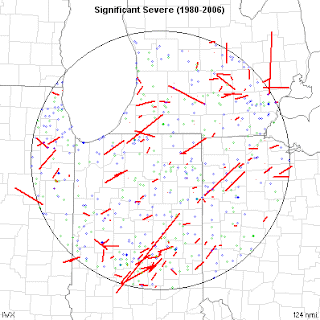
Let's break down the last 70 years or so. Quality reporting dramatically increased during the 1950's and beyond. That's why many of the maps you will see start mid-way through the 20th century. Below are two maps. The first are severe weather reports over the past 30 years or so. You'll notice no county or area is spared. Severe weather can happen anywhere. There are no voids due to 'valleys', rivers, cities, etc.


This second map is of 'significant severe weather'. That is a strong/violent tornado, large hail or very strong straight line winds. As you would expect, the map is not as covered as the first. While severe weather can happen anywhere in our area, there are a few patterns to be seen. The most notable being tornado paths. Most either go from the southwest to the northeast, or from the northwest to the southeast. If you have followed severe weather, you'll know that most tornadoes do go from SW to NE. But many times in our area, summertime thunderstorm travel from the NW to the SE. It is common. Don't be caught off guard by it. 

So how 'much' severe weather do we see each year? 

Tornadoes:
Typically NW Ohio/SE Michigan averages around 4 tornadoes per year and a strong tornado around every 10-15 years. Not very often compared to some parts of the country, but often enough for me! 

Straight line winds:
This tends to be the most widespread of our severe weather threats each year. Winds can form during strong thunderstorms in the spring/summer, deep low pressure system in the autumn, and blizzards in the winter. The most damaging straight line threat comes from a thunderstorm complex called a 'derecho' The southern Great Lakes averages one of the storms per year. Learn more: http://www.spc.noaa.gov/misc/AbtDerechos/derechofacts.htm


When does severe weather tend to strike?
If you have lived in this area long enough, you know that thunderstorms can come along at anytime of the year. Our heightened months tend to be June and July. This is when the jet stream is retreating north into Canada and instability/moisture from the Gulf of Mexico has returned. 

A 'second season' of severe weather also tends to occur in October/November. This is due to the same process as above, but reversed. The jet stream is moving back south with some instability still possible. 

Remember, these are only the peak months. Some of our largest severe weather outbreaks have occurred during other months. Take for example the Palm Sunday Tornado outbreak of 1965. Never let your guard down, simply because of what the calendar says.  

What to learn more? Check out these links: 


Want to become a 'StormTrack Spotter'!?
You don't have to know much or anything about storms to join. We just want individuals who will participate by safely snapping photos and provide quality information. Check out this link for more info on signing up: http://tnnstormtrack.blogspot.com/2013/06/stormtrack-weather-spotter-sign-up.html

Wednesday, November 6, 2013

This Date in 1871

Did you know that Toledo was one of the original weather reporting cities for the Weather Bureau (You know it as the U.S. National Weather Service) in the late 1800's? At the time, Toledo was an important port city on the Great Lakes. 
 
Today we have the luxury of satellites, radars and advanced computer equipment to help in forecasting. But back in the 1800's there wasn't as much technology. In fact typically only once-a-day measurements of temperature, wind direction and barometric pressure. 


Grant was president when the Weather Bureau was created
In 1869, routine observations via telegraph were being made daily in the United States. These reports were then charting, allowing for the first time an attempt to forecast the weather. This was especially important for maritime and agriculture interests at the time. 

Just for fun, we went back into the records and found today's weather in 1871. 

November 6, 1971
Notice how the western United States does not have many stations. Not many people lived there and many territories were not even states yet. Really the only reporting stations are where the transcontinental railroad had been build and near the coast. 

Tuesday, November 5, 2013

100th Anniversary of the 'White Hurricane'

Think of a ship sinking during bad weather in the Great Lakes and the name that comes to mind is likely the 'Edmund Fitzgerald'. But 100 years ago this weekend a storm battered and bruised the fresh water shipping industry like never before...or since.

The Henry B. Smith was sunk on Lake Superior during the storm

It was dubbed the 'White Hurricane' and the 'Freshwater Fury' after the storm sunk 12 ships and grounded at least another 30 more on the Great Lakes. This was a time when meteorology was more of a 'wait and react' business compared to the days ahead forecasting provided today. Ships were also build using materials that struggled to fight against the bitter cold and punishing waves.

Location of the shipwrecks from the storm

The system was actually a combination of two weather makers. A large trough driving through the heart of the country picked up a low pressure center moving up the east coast. The two combined to 'bomb' a low through the Great Lakes. The intense pressure gradient created winds 60-80 mph.

While winds were a big impact to the shipping industry, snow was another big effect from the storm. Cleveland reported over 17" of snow in a 24 hour period. Smashing the 24-hour record. Lake effect snow was reported from Northern Michigan to Buffalo.


November 9th, 1913 morning weather map


The National Weather Service has provided a ton of information on the storm. Check it out here