Today is the last day of February (wow!), which means the old English proverb-- in like a lion, out like a lamb-- will be cited several times today. But will March live up to the hype?
 |
| This has to be photoshopped... right? |
Instead, let's say, 'in like a lion-cub', to describe the upcoming transition into March. Weather will remain wintry and cold. Plus, with the chance of snowfall within the next 7 days, it would be wrong to classify this as a 'lamb-like' start to the month. However, there is warmth and sunshine on the horizon, so there is a silver lining.
 |
| Cute! But fierce. |
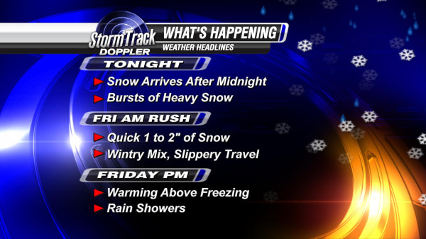
FORECAST
Thursday: Temperatures are starting off steady from
overnight in the lower 30s-- near freezing. Snow will be falling
just south and east of the Toledo metro area,
accumulating up to 0.5''. Early snowfall and breezy winds could reduce
visibilities on/off.
Flurries are also possible Thursday afternoon, but any
accumulation will occur mainly before noon. Highs will reach the middle
30s today. Breezy.
 |
| The Last Day of February |
Friday: Slightly cooler with temperatures barely reaching the lower 30s and cloudy skies.
This Weekend: Sunshine finally returns. Saturday and Sunday will be partly cloudy, but staying cool. Highs in the upper 20s/lower 30s.
This Weekend: Sunshine finally returns. Saturday and Sunday will be partly cloudy, but staying cool. Highs in the upper 20s/lower 30s.