Saturday, April 30, 2011

April 27th Tornado Outbreak Timeline

***INFORMATION IS STILL BEING GATHERED BUT HERE IS A TIME LINE ON THE CONFIRMED TORNADOES, WATCHES AND WARNINGS SO FAR.***This information is also viewable on the storm chasing website http://www.convectiveaddiction.com

Week of April 18-24th:

Long and Medium range models begin to indicate that another

outbreak of severe weather is possible the following week. By this point April has

already broken all-time records for number of tornadoes.


APRIL 25th:

The Storm Prediction Center in Norman, Oklahoma issues its first probability outlook

for a severe weather outbreak on April 27th.
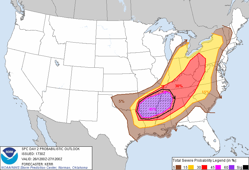
20110425 1730 UTC Day Probabilitic Graphic

Meanwhile a significant severe weather outbreak and heavy rain event in its own respect

was ready to unfold on this day. A high enough threat that the NWS issued a Public

Information Statement on the day.


APRIL 26th


5:02 AM: Birmingham, AL AFD (Area Forecast Discussion) mentions the likelihood for long tracked

tornadoes


HARD TO PINPOINT EXACTLY

WHERE INITIAL DEVELOPMENT WILL TAKE PLACE...WHETHER IT IS ACROSS OUR

AREA OR TO OUR WEST. COULD BE A COMBINATION OF BOTH...BUT MOST

LIKELY LOCATION FOR DEVELOPMENT WILL BE IN THE NORTH WHERE THE CAP

ERODES

QUICKER AND THE AIRMASS WILL BE MORE UNSTABLE. ALL MODES OF SEVERE

WEATHER ARE POSSIBLE WEDNESDAY...INCLUDING LONG LIVED SUPERCELLS AND

TORNADOES.

7:34AM: Severe weather threat across AR, OK, TX, LA for Tuesday increases to prompt

the SPC to issue a DAY 1 HIGH RISK.


12:30 PM: A very complicated and significant appearing weather situation is expected on

Wednesday. SPC highlights a large region in the eastern US for the threat of high wind

damage and tornadoes.


APRIL 27th


1:10 AM: The overall evolution of storms has become much clearer as short range

models indicate a potential historic tornado outbreak may unfold later in the day across

the Deep South. SPC upgrades parts of AL, MS, TN and GA to a HIGH RISK.


2:25 AM: The first tornado watch over Alabama is issued. It also includes parts of MS

and TN.


2:29 AM: Choctaw and Webster County MS EF-3 Tornado hits.

6:45 AM: Dekalb County AL Tornado reaches EF-4 strength.


[caption id="" align="alignnone" width="360" caption="Dekalb County Tornado Damage"][/caption]


8:10 AM: Second round of severe thunderstorms prompts another tornado watch over MS

and AL to be issued.


11:05 AM: PDS (Particularly Dangerous Situation) Watch is issued over MS, LA and

AR as the atmosphere begins to reload from overnight and early morning convection.

This watch replaces parts of the tornado watch issued at 8:10.


1:39 PM: Lafayette Co. MS EF-3 Tornado begins.

1:45 PM: Second PDS Watch issued for AL, TN and MS. All probabilities on the watch

indicate >95% chance for significant severe weather in all categories.
)To the authors knowledge that was the first time ever probabilities were listed that high.)

2:30 PM: EF-4 Philadephia, MS tornado touches down.

3:00 PM: Approximate time for first radar returns of Tuscaloosa/Birmingham Supercell.

3:04 PM: Chicksaw and Monroe Co. EF-3 Tornado strikes.

3:05 PM: Violent Hackleberg, AL EF-4 Tornado

[caption id="attachment_3081" align="alignnone" width="350" caption="Hackleburg, AL Jeep Wrangler Plant Destroyed"][/caption]

3:27 PM: Smith County, MS EF-3 touches down for 11 minutes.

3:35 PM: An amazing third PDS watch was issued for TN and NC.

3:44 PM: First EF-5 Tornado strikes Monroe Co. MS. Winds are estimated at 205MPH.

[caption id="attachment_3084" align="alignnone" width="350" caption="Damage Path through Smithville, MS"][/caption]

3:57 PM: Shotsville, AL EF-3 Tornado forms.

4:39 PM: Limestone and Madison Co. AL EF-4 Tornado begins.

[caption id="attachment_3087" align="alignnone" width="350" caption="Limestone County Tornado"][/caption]

4:53 PM: Tornado crosses into Franklin County AL and continues to produce EF-4 damage.

5:08 PM: Newton Co. EF-4 Tornado strikes.

5:10 PM: Haleyville, AL EF-3 Tornado forms.

5:30 PM: Sawyerville/Eoline EF-3 Tornado beings at least 71 mile track.

5:35 PM: EF-3 Tornado crosses AL into GA in Dade County.

5:42 PM: Long lived tornado forms near Raleigh, MS.

[caption id="attachment_3095" align="alignnone" width="350" caption="Long lived Raleigh, MS tornado near Clinton, AL"][/caption]

5:47 PM: Tornado Warning issued for Tuscaloosa, AL for storm which would eventually

strike the town.


6:08 PM: Tornado enters Tuscaloosa city limits.

6:10 PM: Violent Tornado strikes near the University of Alabama campus.

6:23 PM: Argo, AL Violent EF-4 touches down. Remains on the ground through the GA State line (72 miles).

6:38 PM: Tornado Emergency issued for Birmingham, AL.

6:50 PM: As tornadic supercells push east and fourth PDS watch is issued for AL, GA,

TN, SC, and NC.


7:14 PM: Long tracked Raleigh, MS tornado crosses from MS into AL. It has already been on the ground for 65 miles.

7:50 PM: Argo Tornado crosses from AL into GA. While not as strong, it remains on the ground for 3 more miles.

8:15 PM: Catoosa, GA EF-4 Tornado touches down.

8:29 PM: EF-4 Tornado is on-going in Hamilton Co. TN

9:20 PM: EF-3 tornado develops in Bartow county GA and travels through Cherokee and

Pickens counties.


9:40 PM: Storms along the dry line are still cause for concern, prompting another series

of tornado watches in AL/MS/GA


10:18 PM: Tuscaloosa storm looses supercell characteristics over North Carolina.

APRIL 28th


12:03 AM: Meriwether County, GA EF-3 tornado touches down.

12:38 AM: EF-3 tornado forms in Pike County GA and moves through Lamar, Monroe

and Butts County.


3:15 PM: The last tornado watch of the outbreak is issued.


Pics Courtesy: Jackson Weather Examiner, The Decatur Daily

Severe Outbreak Review

The National Weather Service has compiled a report about the record-setting tornado outbreak from this past week.

http://www.noaanews.noaa.gov/april_2011_tornado_information.html

Friday, April 29, 2011

2nd Wettest April

The next chance of rain is later Saturday night, so we will probably get to May 1st with no additional rainfall.  This brings the monthly total to 6.33", making it the 2nd wettest April on record in Toledo.  It is also 3.29" above normal.

Thursday, April 28, 2011

Updated rain total

April rainfall for Toledo Express has now hit 6.29", which is now 3.25" above normal.  This makes it the 2nd rainiest April on record.

We would need to receive 0.84" of rain before midnight Sunday morning to tie the #1 record spot, but it looks like any additional rainfall between now and then would not be very heavy.

Strong wind gusts

Here are some wind gusts from 4-6 am this morning:

  • 68 mph - Findlay

  • 67 mph - Lima

  • 60 mph - Perrysburg, Sandusky, Metcalf Field

  • 46 mph - Monroe

  • 41 mph - Defiance

  • 40 mph - Monroe

  • 38 mph - Hillsdale

Severe Weather Stats

Having severe weather this time of year is not unusual at all.  The amount of it, though, is running way ahead of normal levels.

So far this month, 886 tornadoes have been reported in the United States.  Surveys and studies are still being conducted on confirming how many reports were actual tornadoes.

Last April, the number of actual tornadoes was 139 (226 in 2009 and 189 in 2008).  The "normal" amount of April tornadoes runs around 185.

The number of reported tornadoes for the year thus far is 1078.  For this period, the normal value is around 378.  (Again, "reported" tornadoes does not mean officially confirmed--since multiple reports of the same tornado can be included).

So far this year, 45 people have died in 15 tornadoes.  This represents the same amount killed in ALL of 2010 in 21 tornadoes.

May, June & July are very active months, with June being the statistical high point of tornado occurrence.  So, the severe season has a long way to go.

Wednesday, April 27, 2011

April rain update

Updated total for April rainfall is 5.99" as of 4 pm today.  This makes it the 3rd wettest April on record.  We could go higher -- there is the potential for another 1"+ rain before rain shuts off later Thursday.

Sunday, April 24, 2011

River Levels

Here are links to the latest river levels and forecasts from the National Weather Service.  Please continue to check the links if you live near a river, as the forecasts will be updated every few hours. 

Northwest Ohio River Levels

Northwest Ohio (closer to Indiana border)

Southeast Michigan

Wettest April Ever?

A rainfall accumulation of around 2.5 inches or more between Sunday night and Thursday would push our monthly total over 7".  This would make April 2011 the wettest on record for Toledo Express Airport.  If rainfall this week falls short of 2", it would still put this month into the top 5.

Saturday, April 23, 2011

More rain

After seeing some decent rainfall over the last week, more is in the forecast for the week ahead.  Occasional showers and thunderstorms could dump 2 to 5 inches of rain between Monday morning and Thursday morning.  We will continue to monitor the situation for any flooding concerns.

St Louis -- initial tornado surveys completed

From the National Weather Service's St Louis office:   http://www.crh.noaa.gov/lsx/?n=04_22_2011

SURVEY TEAM RATE DAMAGE AT LAMBERT ST. LOUIS INT'L AIRPORT AS EF 2

The National Weather Service damage survey team at Lambert St. Louis International Airport has found EF-2 damage.  Nearly 80% of the windows in the easternmost part of the terminal were blown out...and the roof was torn off of Terminal C.    EF-2 damage indicates winds of 111 to 135 mph.

 INITIAL DAMAGE SURVEY INDICATES EF 4 DAMAGE IN NORTH ST LOUIS COUNTY

 The National Weather Service damage survey team in north St Louis county has found EF-4 damage in the Bridgeton area...near old St Charles Rock Road and Harmon Estates.   EF-4 damage indicates winds of 166 to 200 mph.

Friday, April 15, 2011

Weekend Outlook

A storm will track across the area Saturday, keeping occasional showers around.  Severe weather will break out across the southern states, while we will notice the wind.

Winds will continue to gust above 30 mph the entire weekend.  Gusts will even exceed 40 mph at times.  The winds will relax a little heading into Monday.

Rain from the weekend system will taper off for Sunday, but we could pick up over 1" of rain before that happens.

Winds and Waves

The very strong easterly winds have been creating a problem for those who live near the lake.  These strong winds are pushing the water towards the western shoreline, causing waves over 6 feet high.  Lake levels have risen quite a bit, so those waves are riding on top of the higher water.  (Lake levels in the eastern parts of Lake Erie have dropped -- the winds are literally pushing the water from one side of the lake to the other).

Waves have been crashing against breakwalls, and some of the water may jump over.  There is the threat of some water hitting roadways near the lakeshore.

Monroe county in Michigan has issued a coastal flood warning.  More details HERE.

The situation will improve Saturday as winds become southwesterly.  Winds will be primarily westerly on Sunday, so this will slosh the water back eastward to the other side of the lake.  Our lake levels will drop quite a bit from their current state.

Sunday, April 10, 2011

Sunday Historical Records

Severe Outbreak

A cold front will pass through our area Monday with some showers and storms.  While a few storms may be strong and gusty, the risk of severe weather will be low due to the timing of the day, and the strongest energy staying out of our area.

However, a severe weather outbreak will occur in the western Great Lakes through the Mississippi Valley.  Areas west & northwest of Chicago have a moderate risk of t0rnadoes Sunday into Sunday night.

Saturday, April 9, 2011

Weekend Warming

Winds off the lake combined with some clouds will keep temps rather cool near the lake.  Highs well south and west of Toledo will get close to 70°.

A warm front will push through the area Sunday morning, allowing southwesterly winds to push temps into the upper 70s and lower 80s.  Sunday's record high for Toledo Express is 83° set back in 1977.


Thursday, April 7, 2011

Huge Warm-Up

A strong storm system will approach this weekend, allowing much warmer air to surge into the area.  High temperatures Sunday will be 2011's warmest.

This same storm will cause severe weather to our west much of the weekend.  We could see some strong storms Sunday night into Monday morning.  Stay tuned for updated forecasts.

Saturday, April 2, 2011

April Almanac

Normal high & low:

April 1        53° / 33°

April 30     65° / 43°

Records:  89° / 8°

Normal precip:  3.24"

Average snowfall:  1.3"