Thursday, March 28, 2013

Signs of Spring

Another beautiful morning is yet again finally showing a sign that spring is going to show up after all.  Here is how this morning looked a little before 9 AM.  Blue skies and sunshine!


Now for some forecasting fun.  Did you notice the puffy looking cumulus clouds develop Wednesday afternoon?  That's likely to happen again and here is why.  The sun angle this time of the year is much greater and stronger.  This provides more energy to the lower atmosphere that will eventually fuel spring storms and summer heat.  Here is a diagram of the atmosphere later this afternoon in the form of something called a Skew-T model.  I'll point out two things, first a very steep lower level lapse rate that will allow air to freely rise this afternoon and secondly available lower level moisture. 


I also look closely at what is known as the Convective Temperature (ConvT).  This is the surface temperature that has to be reached for pure convection, or rising air to occur.  At this point, the sunny start to the morning will quickly be dotted with "fluffy" looking cumulus clouds developing.  This explains how a morning (stable atmosphere) can start off clear and sunny only to be followed by clouds that seem to develop out of the blue.  It is important to note there must be sufficient lower level moisture for the clouds to actually develop.  Later this season, this very process is the same one that often leads to afternoon showers or scattered thunderstorms. 

Saturday, March 23, 2013

Snow Still Going South

Toledo and much of Northwest Ohio will continue to be on the dry side of a system that will bring heavy rain/snow to the Ohio River Valley. Places like Missouri, Illinois, and Indiana could see over 8" of snow. Locally a dry northeast wind and a weakening system will mean any snow will likely remain well south of the Toledo Metro.

Here is our latest snow forecast:

Monday, March 18, 2013

March 18th Cedar Point Timelapse

Early morning freezing rain made for a unique view from high on top of the 'Top Thrill Dragster' with fog developing late in the afternoon as winds went calm.


Sunday, March 17, 2013

Spring is How Close?

The recent stretch of colder than average air has many in Ohio and Michigan asking: 'Where is spring!?'

Our calendars say spring starts on Wednesday but long range weather charts show winter isn't ready to make the switch just yet. Highs much of this week will remain in the 30s, around 10-20 degrees below average.


Just to add some insult to injury, look how much colder the next few days will be compared to last year.

Wednesday, March 13, 2013

Spring Fever On Hold This Year

It was this time last year the flowers began an early spring bloom, golf courses were packed and spring fever was in full spring.  The accelerator was floored on the warm-up as temperatures soared into the 70s and 80s for nearly a week and a half en route to the warmest March on record!  The average temperatures for March was 51.4° a whopping +13.0° above normal!  Here are some additional records and milestones from last March:


This is March after all and is often considered one of the most volatile months where huge swings and changes in weather can happen as the seasonal transition occurs.  It's misleading to state "what a difference a year can make" because there is little if any connection from a season one year to the next.  However, this March is so far is a HUGE difference compared to the last.  So far this month the average is 33.1° which is -0.9° below average and that likely to trend lower over the next week.  Here is a cool perspective on this March and the forecast compared to the record warmth for March of 2012:

 
Hold off spring fever for a little bit longer, spring is going to take its time getting here this season! 

~Meteorologist Chris Vickers

Thursday, March 7, 2013

Is it Typical to be Near Normal?

Having just wrapped up the first week of March, temperatures have yet to reach, or exceed, 'normal' for this time of year.

On average, the first week of March should yield temps in the low/mid 40s, but so far this month, Toledo's daily highs have been overwhelmingly cool, settling in the 20s and 30s. 

Max Toledo Daily Temps: March

Normals and Records for Toledo Express Airport Reporting Site


So, what does this indicate for the rest of the month? Nothing.

Being at, or near normal, isn't always 'typical' at any time of year. The normal temp represents the average temperature for any given date based on years of record-keeping and mean-value calculations. So, for example, if over the course of 5 years, the high temperature on March 7th was 37°, 49°, 17°, 44°, and 68°, the average, or 'normal' high is 43°, but it was never actually 43° on the dot any of those years. 

I can also confidently say that this weekend's upcoming warm-up doesn't mark the end of winter. More on that to come.

FORECAST:   
Sunshine peeking through the clouds Thursday. Highs in the upper 30s/lower 40s. Skies clear overnight, allowing everyone to see a fair share of sunshine on Friday to wrap up the work week. 

Highs will skyrocket into the 50s this weekend.
And, don't forget to turn your clocks ahead on Saturday evening.

Daylight Saving Time Begins Saturday-Sunday

One final thought:
A hydrological report by the NWS warns residents in far NW Ohio and SE Michigan that received snow on Tuesday about the possibility of some minor flooding next week. Snow will melt this weekend, saturating an already wet ground & leading to increased runoff and rising river levels. In addition, there's a band of moderate to heavy rain showers possible Sunday into Monday, adding to those already high water levels. Keep this in mind if you're in a flooding prone area.

Monday, March 4, 2013

Tuesday Snow Update (Noon Update)


Tuesday Snow Update

While sunny skies are expected for most of the day Monday, we are tracking more snow on the way Tuesday. The forecast for Monday has highs into the 30s with clouds holding off until late in the day. Enjoy the sunshine!


The low pressure system will grab some Gulf of Mexico moisture early Tuesday and create heavy snow from Chicago to Dayton. A dry wind off Lake Erie will likely keep accumulations lower the further north in Ohio you live. The heaviest snow will be falling Tuesday evening, likely near or just after the evening commute.


We will need to keep an eye on this system with a few miles (as always) making a big difference in snow fall accumulations. Here is our latest forecast with snow accumulations through Wednesday morning with the heaviest snow SOUTH of Toledo.
 
Stay Tuned for more updates.

Sunday, March 3, 2013

Tuesday Snow Chances

Following what was the snowiest month of the winter season in February, March has been relatively quiet. So far Toledo has only recorded a 'Trace' of snowfall, around an inch below the early March average. That could change on Tuesday with a Clipper snow maker that is expected to move into the southern Great Lakes.

There are still lots of details to resolve as this system is just coming onshore in the Pacific northwest but here is what our hour-by-hour forecast is showing on Monday. The system is still west of Toledo with mostly sunny skies expected much of the day. 


By Tuesday the clipper will combine with an upper level disturbance from the south. Exactly how the storms combine and move east will determine where the heaviest snow falls. Right now snow is expected to spread into the Great Lakes Tuesday morning, but again the exact track still a bit up in the air. The 'cone of uncertainty' for the low path is from Central Ohio to Tennessee at this point.


Our hour-by-hour forecast does show snow impacting Toledo and surrounding counties Tuesday morning though and we will use this as a good starting point for where and when the snow begins.


This is a storm that will need to be watched closely the next few days with the possibility for several inches of snow accumulation. Stay Tuned.

Friday, March 1, 2013

February in Review... Up Next: March

February is over, so this is the time to look back and see how 2013 stacks up.

With the exception of no 'major' winter storms, February followed a very typical winter pattern, resulting in an average monthly temperature just below normal, and monthly snowfall totals just above normal.
 
Average Monthly Temp: 28.3°
Actual Monthly Temp: 26.8°
Departure from Normal: -1.5°
 
Average Monthly Snowfall: 9.4"
Actual Monthly Snowfall: 12.4"
Departure from Normal: +3.0"
Meteorologically speaking, March 1st is the beginning of Spring. I know the actual first day of spring isn't until March 20th, but for compiling data and consistent record keeping, let's say February 28th is the last day of winter. Therefore:
 
2012 Dec-Mar snowfall: 15.7"
2013 Dec-Mar snowfall: 22.5"
Avg. Dec-Mar snowfall: 28.4"
2013 Departure from Normal: -5.9"

So even though we've blown last year's December-March snowfall totals out of the water, we've still landed below the 'norm'. Perhaps it is because of the lack of any one 'big' winter storm?
*Notice* February's total snowfall was accountable for over 50% of the season's total snowfall. Not bad for the shortest month of the year ;)
 
The shortest month yielded the most snow!
 
Time for a history review:
 
What do you remember about March 2012??

For me, the memory that stands out the most, is waiting for the St. Patrick's Day parade to begin while sweating bullets and drinking bottle after bottle of.... water.

 March 2012 was VERY warm. The warmest on record, in fact, yielding 11 Days above 70°, shattering the old record of 5 days set in 1995.

80s in March? Not this year.


So where are we, one year later? Not even close.

At this time of year, average high temps should be in the lower 40s and average lows should be in the middle 20s. We will approach that towards the middle and end of next week.
 
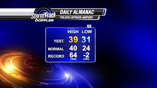
40s and 20s: The norm for March 1st.

FORECAST

So it's a cold start to March.

Highs in the upper 20s and lower 30s Friday, and through the weekend. C
loudy and breezy.

The sun makes an appearance several times over the next few days, but it will struggle to help warm us up much. Keep the parka handy! We're not done with the cold, or the snow, yet this season.