
Week of April 18-24th:
Long and Medium range models begin to indicate that another
outbreak of severe weather is possible the following week. By this point April has
already broken all-time records for number of tornadoes.

APRIL 25th:
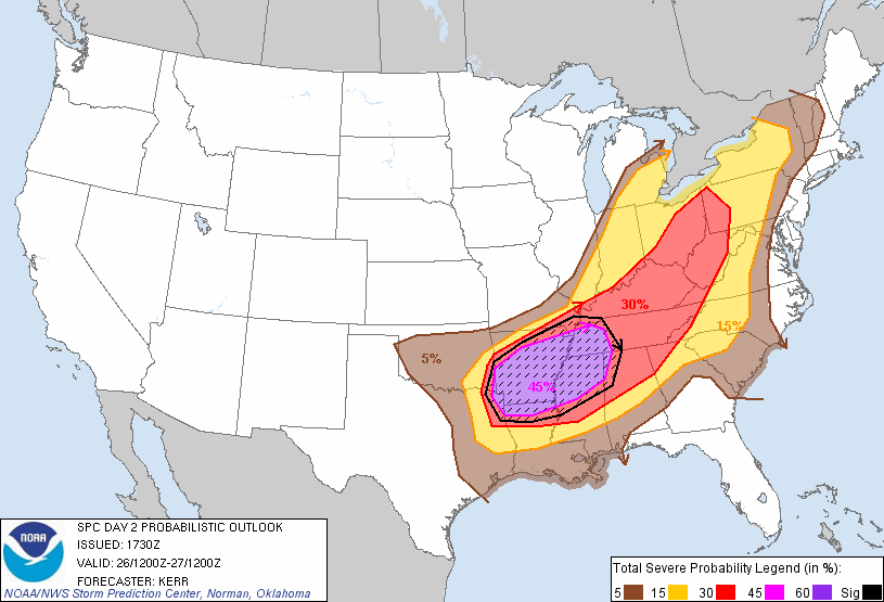
The Storm Prediction Center in Norman, Oklahoma issues its first probability outlook
for a severe weather outbreak on April 27th.
Meanwhile a significant severe weather outbreak and heavy rain event in its own respect
was ready to unfold on this day. A high enough threat that the NWS issued a Public
Information Statement on the day.
APRIL 26th
5:02 AM: Birmingham, AL AFD (Area Forecast Discussion) mentions the likelihood for long tracked
tornadoes
HARD TO PINPOINT EXACTLY
WHERE INITIAL DEVELOPMENT WILL TAKE PLACE...WHETHER IT IS ACROSS OUR
AREA OR TO OUR WEST. COULD BE A COMBINATION OF BOTH...BUT MOST
LIKELY LOCATION FOR DEVELOPMENT WILL BE IN THE NORTH WHERE THE CAP
ERODES
QUICKER AND THE AIRMASS WILL BE MORE UNSTABLE. ALL MODES OF SEVERE
WEATHER ARE POSSIBLE WEDNESDAY...INCLUDING LONG LIVED SUPERCELLS AND
TORNADOES.
7:34AM: Severe weather threat across AR, OK, TX, LA for Tuesday increases to prompt
the SPC to issue a DAY 1 HIGH RISK.
12:30 PM: A very complicated and significant appearing weather situation is expected on
Wednesday. SPC highlights a large region in the eastern US for the threat of high wind
damage and tornadoes.
APRIL 27th
1:10 AM: The overall evolution of storms has become much clearer as short range
models indicate a potential historic tornado outbreak may unfold later in the day across
the Deep South. SPC upgrades parts of AL, MS, TN and GA to a HIGH RISK.
2:25 AM: The first tornado watch over Alabama is issued. It also includes parts of MS
and TN.
2:29 AM: Choctaw and Webster County MS EF-3 Tornado hits.
6:45 AM: Dekalb County AL Tornado reaches EF-4 strength.
[caption id="" align="alignnone" width="360" caption="Dekalb County Tornado Damage"][/caption]
8:10 AM: Second round of severe thunderstorms prompts another tornado watch over MS
and AL to be issued.
11:05 AM: PDS (Particularly Dangerous Situation) Watch is issued over MS, LA and
AR as the atmosphere begins to reload from overnight and early morning convection.
This watch replaces parts of the tornado watch issued at 8:10.
1:39 PM: Lafayette Co. MS EF-3 Tornado begins.
1:45 PM: Second PDS Watch issued for AL, TN and MS. All probabilities on the watch
indicate >95% chance for significant severe weather in all categories. )To the authors knowledge that was the first time ever probabilities were listed that high.)
2:30 PM: EF-4 Philadephia, MS tornado touches down.
3:00 PM: Approximate time for first radar returns of Tuscaloosa/Birmingham Supercell.
3:04 PM: Chicksaw and Monroe Co. EF-3 Tornado strikes.
3:05 PM: Violent Hackleberg, AL EF-4 Tornado
[caption id="attachment_3081" align="alignnone" width="350" caption="Hackleburg, AL Jeep Wrangler Plant Destroyed"]
 [/caption]
3:27 PM: Smith County, MS EF-3 touches down for 11 minutes.
3:35 PM: An amazing third PDS watch was issued for TN and NC.
3:44 PM: First EF-5 Tornado strikes Monroe Co. MS. Winds are estimated at 205MPH.
[caption id="attachment_3084" align="alignnone" width="350" caption="Damage Path through Smithville, MS"]
 [/caption]
3:57 PM: Shotsville, AL EF-3 Tornado forms.
4:39 PM: Limestone and Madison Co. AL EF-4 Tornado begins.
[caption id="attachment_3087" align="alignnone" width="350" caption="Limestone County Tornado"]
 [/caption]
4:53 PM: Tornado crosses into Franklin County AL and continues to produce EF-4 damage.
5:08 PM: Newton Co. EF-4 Tornado strikes.
5:10 PM: Haleyville, AL EF-3 Tornado forms.
5:30 PM: Sawyerville/Eoline EF-3 Tornado beings at least 71 mile track.
5:35 PM: EF-3 Tornado crosses AL into GA in Dade County.
5:42 PM: Long lived tornado forms near Raleigh, MS.
[caption id="attachment_3095" align="alignnone" width="350" caption="Long lived Raleigh, MS tornado near Clinton, AL"]
 [/caption]
5:47 PM: Tornado Warning issued for Tuscaloosa, AL for storm which would eventually
strike the town.
6:08 PM: Tornado enters Tuscaloosa city limits.
6:10 PM: Violent Tornado strikes near the University of Alabama campus.
6:23 PM: Argo, AL Violent EF-4 touches down. Remains on the ground through the GA State line (72 miles).
6:38 PM: Tornado Emergency issued for Birmingham, AL.
6:50 PM: As tornadic supercells push east and fourth PDS watch is issued for AL, GA,
TN, SC, and NC.
7:14 PM: Long tracked Raleigh, MS tornado crosses from MS into AL. It has already been on the ground for 65 miles.
7:50 PM: Argo Tornado crosses from AL into GA. While not as strong, it remains on the ground for 3 more miles.
8:15 PM: Catoosa, GA EF-4 Tornado touches down.
8:29 PM: EF-4 Tornado is on-going in Hamilton Co. TN
9:20 PM: EF-3 tornado develops in Bartow county GA and travels through Cherokee and
Pickens counties.
9:40 PM: Storms along the dry line are still cause for concern, prompting another series
of tornado watches in AL/MS/GA
10:18 PM: Tuscaloosa storm looses supercell characteristics over North Carolina.
APRIL 28th
12:03 AM: Meriwether County, GA EF-3 tornado touches down.
12:38 AM: EF-3 tornado forms in Pike County GA and moves through Lamar, Monroe
and Butts County.
3:15 PM: The last tornado watch of the outbreak is issued.


Pics Courtesy: Jackson Weather Examiner, The Decatur Daily
No comments:
Post a Comment