We are fine tuning the details on back to back ALERT days on Wednesday and Thursday and more information comes in. Each day brings different, distinct threats. Wednesday will bring heavy rain. Thursday will bring accumulating snow and very gusty winds.
 |
| WTOL ALERT Days |
Heavy rainfall may begin by midday on Wednesday. Rounds of rain will bring 1 to 2" of rain through Wednesday night. Localized minor flooding may be possible. Pay especially close attention to basement flooding in prone areas.
 |
| Projected Rainfall Wednesday |
Will we see a Winter Storm? Overnight Wednesday and into Thursday morning the rain will change over to snow. (Most likely before daybreak) Uncertainty in snow accumulations still exists! However, several inches of accumulating snow is possible on Thursday along with gusty winds. The zone of heaviest snow -- 6" or more -- will likely be far north and west of Toledo and may miss much of the viewing area. Still with that said, several inches of an accumulation will still be possible. This could still be the largest winter storm of the otherwise lackluster winter season. (Greatest 1 day snowfall was November 21st with 3.5")
 |
| Possible Snowfall Thursday |
Additional Technical Weather Information
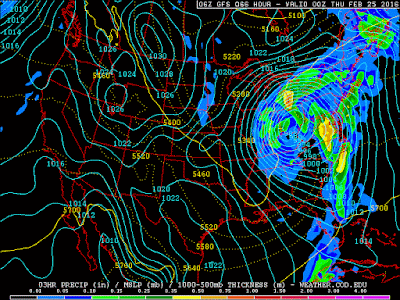
There has been a slight dip south and east in latest model runs which brings colder air into play a bit earlier than Sunday's thinking. If this holds, it may warrant higher snow totals from this storm. This storm system is also rapidly strengthening as it tracks across southern Ohio. A 988 mb low will deepen to 980 mb by Thursday evening. This will generate quite a windy Thursday afternoon. Don't discount the very large impact strong and gusty winds may play into Thursday as well.
 |
| GFS Model Prog for Wednesday Evening |
~Meteorologist Chris Vickers

No comments:
Post a Comment