Severe Weather Climatology
Before we can dive into individual storms and how the atmosphere works, we must understand a broad picture about severe weather. How often does it really happen? In northern Ohio and southern Michigan we are no strangers to severe weather. But, we are also far from the first place you likely think of for damaging and destructive storms.
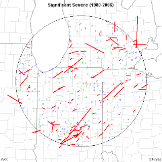
Let's break down the last 70 years or so. Quality reporting dramatically increased during the 1950's and beyond. That's why many of the maps you will see start mid-way through the 20th century. Below are two maps. The first are severe weather reports over the past 30 years or so. You'll notice no county or area is spared. Severe weather can happen anywhere. There are no voids due to 'valleys', rivers, cities, etc.
This second map is of 'significant severe weather'. That is a strong/violent tornado, large hail or very strong straight line winds. As you would expect, the map is not as covered as the first. While severe weather can happen anywhere in our area, there are a few patterns to be seen. The most notable being tornado paths. Most either go from the southwest to the northeast, or from the northwest to the southeast. If you have followed severe weather, you'll know that most tornadoes do go from SW to NE. But many times in our area, summertime thunderstorm travel from the NW to the SE. It is common. Don't be caught off guard by it.
So how 'much' severe weather do we see each year?
Tornadoes:
Typically NW Ohio/SE Michigan averages around 4 tornadoes per year and a strong tornado around every 10-15 years. Not very often compared to some parts of the country, but often enough for me!
Straight line winds:
This tends to be the most widespread of our severe weather threats each year. Winds can form during strong thunderstorms in the spring/summer, deep low pressure system in the autumn, and blizzards in the winter. The most damaging straight line threat comes from a thunderstorm complex called a 'derecho' The southern Great Lakes averages one of the storms per year. Learn more: http://www.spc.noaa.gov/misc/AbtDerechos/derechofacts.htm
When does severe weather tend to strike?
If you have lived in this area long enough, you know that thunderstorms can come along at anytime of the year. Our heightened months tend to be June and July. This is when the jet stream is retreating north into Canada and instability/moisture from the Gulf of Mexico has returned.
A 'second season' of severe weather also tends to occur in October/November. This is due to the same process as above, but reversed. The jet stream is moving back south with some instability still possible.
Remember, these are only the peak months. Some of our largest severe weather outbreaks have occurred during other months. Take for example the Palm Sunday Tornado outbreak of 1965. Never let your guard down, simply because of what the calendar says.
What to learn more? Check out these links:
Want to become a 'StormTrack Spotter'!?
You don't have to know much or anything about storms to join. We just want individuals who will participate by safely snapping photos and provide quality information. Check out this link for more info on signing up: http://tnnstormtrack.blogspot.com/2013/06/stormtrack-weather-spotter-sign-up.html


No comments:
Post a Comment