Early this week an upper level low pressure will sit over the eastern Great Lakes. Breeding grounds for waterspouts. Take a look at this picture taken back in August when a similiar set-up occured.
There is a difference this time around though. The August low (in red) was right over Lake Erie, this time around (in blue) the low will be further north. On a map that might not look like much, but that few hundred miles is critical.
The National Weather Service has a great chart as well to take a simple, quick look to guage if the atmosphere is primed for possible waterspouts. I have outlined where the western half of Lake Erie sits on Tuesday. It is right on the edge of a favorable set-up.
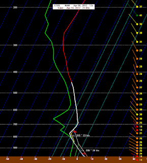
So why does this happen? These whirlwinds tend to occur more frequently when cold air is dumped over the warm waters during the transitional seasons (fall and spring). Below I have placed a forecast sounding for Toledo, late Tuesday.. Lake temperatures are about 8 degrees Celcius (49 F) and air temperatures a mile above the surface are expected to be 15-17 degrees C colder than the water. A significant difference that will lead to possible convection Tuesday.
This perfect set-up for lake effect precipitation but with northwest winds, the highest chance for convection will be between Cleveland and Buffalo.
Another side effect of this lake effect precipitation is the possiblity of rain and yes, snow. But again, the highest chances are from Erie County and east. This system is a strong early spring one and bears watching, but you'll likely have to head east of Toledo for any shot at a waterspout and snow!


No comments:
Post a Comment