Tuesday, December 30, 2014

Coldest Year Ever For Toledo?

Have you celebrated less than 37 birthdays in your life and lived in northwest Ohio?

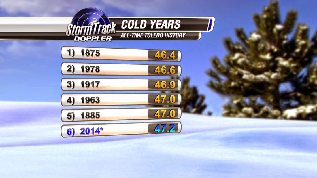
If you answered yes to both, then this was the coldest year ever lived through. In fact only two years ('78 and '63) have been colder in the past 100 years in Toledo.


There are still a few more hours to make it official but it is very likely 2014 records an average temperature of just 47.2 degrees. The coldest month was January with an average temperature of just 16 degrees! Although the mild December spoiled any chances to break the record for coldest year ever recorded in Toledo. I have a feeling many will be okay missing the mark on that record.

Looking ahead too, the first few hours of 2015 look to start off very cold as well!


Monday, December 29, 2014

Snow? What Snow?

After a frigid and even snowy start to November, this has been one very quiet December so far as any wintry weather goes. Through 28 days only a 'Trace' of snow has been recorded. It looks likely that this will mark only the third time in Toledo history without measurable snow in December.


And the pattern looks quiet into the first few days of January. Below is a graphic for snowfall accumulations over the next 9 days. The search for winter snow this season will go on...

Wednesday, December 24, 2014

Santa's Bumpy Ride into NW Ohio

As the evening in question arrives, details of tonight's stormy weather are coming into crystal clear focus.

According to this graphical depiction from the Cleveland office of the National Weather Service, 50mph wind gusts, 20-30mph sustained winds, temps falling to the freezing point tonight, thunder, 100% cloud cover, heavy rain and light flurries are all on tap for the next 12-16 hours. 

Santa's about to have a bumpy ride.

NWS Cleveland

While we track forward along with the impending storms, winds continue to pose the greatest threat. With only a few hours of light snow flurries (from 9pm-4am), accumulations are not only unlikely, they're going to be nearly impossible to develop. 

Possible Snow flurries 8pm Wednesday Night: EURO, ECMWF Model

With the absence of widespread slick roadways and treacherous blacktop conditions, wind gusts up to 50mph become the focus of this event. 

Twisterdata.com, Surface Temp, Wind, MSLP: NAM Model
 Law ornaments, decorations, outdoor lights and 8 tiny reindeer statues are at risk of damage and entire removal from your yard. Many Christmas decorations don't weigh much, so make sure your most valuable possessions are brought indoors before the winds pick up. 

Today's timeline looks like this:

  • 2pm: Scattered Rain, Light winds
  • 4pm: Widespread Rain, Increasing Winds
  • 6pm: Heavy rain, Gusty Winds
  • 8pm: Scattered Rain, PEAK Winds
  • 10pm: Light Rain/Snow Mix, PEAK Winds
  • 12am: Flurries, Gusty Winds
  • 2am: On/Off Flurries, Gusty Winds
  • 4am: Flurries, Gusty Winds
  • 6am: On/Off Flurries, Gusty Winds
  • 8am: A Few Snow Showers, Blowing/Drifting Snow
  • 10am: Snow Ends, Breezy

For most of Christmas Day, winds will range between 15-25mph, staying strong, and conditions will be dry.

Merry Christmas!


Sunday, December 21, 2014

Winter Solstice

Tonight marks the beginning of the winter season. For record-keeping purposes, meteorological winter already began December 1st, but astrologically, we are now officially approaching the 'depth of winter'.

The sun's angle to the earth determines seasonal patterns
 With the sun's angle to the earth sinking to its farthest point to the south, we can expect December 21 to have the least amount of daylight. 

Sun warms the southern hemisphere during our winter season
 The sun will still shine through the winter, but with the rays directly overhead in the southern hemisphere, we experience winter while they experience summer. 


Winter officially begins at 6:03pm, December 21. Some years, it may occur earlier or later in the day, even falling on the 20th or 22nd of the month if the sun's angle hits its lowest point before or after midnight. This year, we will experience 9 hours and 9 minutes of daylight on December 21st, making it the 'shortest day' of the year. 


Imminent Christmas Weather

Confidence is growing as we approach the holidays this week. With only slight changes from day-to-day now as the imminent weather moves in, you can start to plan around the worst of it.


Monday will be mild, mainly dry, mostly cloudy and otherwise unremarkable. 

We can start to map out the timeline of this event beginning Monday evening:


After midnight, rain showers arrive. Scattered at first, leading into Tuesday morning. 

Monday night-Tuesday morning (12/22-12/23)
Tuesday will be a mild day with highs near 50°. Showers will track through the area all day long, moderate to heavy at times.

Up to 1/2" of rainfall is possible both Tuesday and Wednesday.


Wednesday morning (12/24)
Showers continue to fuel into the area all day Wednesday. Gulf coast moisture will be trapped over Ohio in a line stretching from Mississippi to Upstate New York.

Travel during the holidays will feel the impacts the most.
According to USA Today, a record number of Americans will be on the road this holiday season. AAA expects 98.6 million people to travel 50 miles or more this Christmas.

Into Wednesday evening, incredibly strong winds will be added to the mix.
Up until that point, however, we're only looking at rain showers. Due to warm air advection, snow is not a possibility until after midnight Wednesday into Thursday-- as Santa is making his deliveries. 


Warmth Monday-Wednesday keeps snow showers at bay until Christmas Day
Winds remain strong into the day Thursday. Some damage is possible-- better bring in those loose decorations now! Expect strongest gusts to be near 40mph at times. 

Rain showers will eventually filter in some snow flakes overnight Wednesday in Thursday with a wintry mix overnight creating slick roadways Thursday morning.

Thursday, snow showers will fall into a wet & newly frozen environment. Slick roadways are not only possible, but likely.


Early morning snow showers possible-- minimal accumualtions
With gusty winds and falling flakes, blowing and drifting snow is likely. Snowfall amounts will be minimal.

In summation:
  1. Monday:                 Dry, cloudy, mild
  2. Monday night:       Mild, Light rain showers arrive
  3. Tuesday:                 Moderate to heavy rain, Warm
  4. Tuesday Night:      Rain showers, Mild
  5. Wednesday:           Moderate to heavy rain, Warm, Gusty Winds
  6. Wednesday night: WINDY, Wintry Mix
  7. Thursday:                WINDY, some snow, Cold


Saturday, December 20, 2014

Pre-Christmas Storm Update

We have been tracking a storm that will impact the area in the days leading up to Christmas for the better part of a week now. As the storm approaches the west coast of the United States we are getting a much clearer picture of how the event will unfold on Tuesday, Wednesday and even Christmas itself. For the local area this will be mostly a mild rain event with very windy conditions.

TUESDAY: Winds will be steady but relatively weak throughout the day from the southwest. Rain showers are expected from near Chicago all the way east to the Atlantic Seaboard.

WEDNESDAY: Heavy rain showers are likely. Highs will climb into the low 50's. Winds will pick up through the day with wind gusts over 40 mph very likely by evening.


CHRISTMAS DAY: Air will turn colder near 30 with a few snow showers and windy conditions continuing. Gusts over 35 mph will continue to be possible. 


BY NEXT WEEKEND: Colder air will return on a more permanent basis. January has all the indications of being one very cold month....


Thursday, December 18, 2014

UPDATE: Next Week Storm Potential

The chance of a storm bringing disruptive weather into Christmas next week remains a likely possibility across the Great Lakes region and up the East Coast.  The likely impacts include:

  • Rain
  • Gusty Winds
  • Snow 

Remember a "Storm" doesn't mean exclusively snow...in fact rain and wind may be some of the larger impacts of this storm. 

Rain will become likely Tuesday and into Wednesday with gusty winds increasing into Christmas Eve.  Rain may change to some snow into Christmas morning bringing with it the chance of a White Christmas.  Differences in model solutions still exist, which is expected.  Some indications have surfaced that the greater energy from this storm may transition to the East Coast.  If this happens, we'd still feel the impacts of this storm with rains prior to Christmas, gusty winds and limited snow showers into Christmas morning.


Great Lakes Storm?

East Coast Storm?

Stay tuned for updates!