Saturday, November 8, 2014

Will 2014 Be a Record Cold Year?

You might shutter at the thought of last winter. But, the cold start to the year combined with a cooler than normal summer and the big chill coming our way later this week may be just enough to propel 2014 into the record books.

If Toledo simply holds right at an average temperature during the month of November and December, the year long average would fall to 47.3. Good enough to tie with 1976 with the 7th coldest year in Toledo history (dating back to the early 1870's). Below is a list of top-10 coldest calendar years on record:

Via NWS Cleveland

So what will it take to make 2014 the coldest year ever record in Toledo? Let's compare the record year of 1875 to where Toledo has been so far this year:


While Toledo is running warmer than the record year of 1875 a very cold airmass is expected the next few weeks, potentially lasting into December.

Pic via twitter: @BigJoeBastardi

Time will tell if 2014 ends up #1 but no matter what, it appears a near lock it will be a top 10 cold year in Toledo history.


Tuesday, November 4, 2014

2014-2015 Winter Outlook

'This will be a terrible winter'.

'It will be worse than last year'.

You've probably heard your own variation of those phrases to sum up forecasts for the upcoming winter. Right?

There is no denying it. Last winter will go down as one of the worst on record for Toledo. It SMASHED all-time snow records and flirted with the unimaginable cold of the last 1970's. So is a repeat really possible? Let's dive into facts, not hype. Winter forecasting is still a VERY difficult science. Just watch this story and information from Meteorologist Robert Shiels:


Although forecasting a season in advance is a difficult task, there are some pre-cursors we can look at to make the best forecast available. Such as global sea temperatures, the position of the jet stream and current snow cover. Here is our forecast:

TEMPERATURE: Below average.

This doesn't mean polar bears will be seen walking down the streets. There will be some fluxuation in temperatures throughout the season.

The key many times to just how bone chilling a winter can get is how quickly snow cover across the northern US becomes established. This will be something to watch closely the next 2 months. Right now there is a significant amount of snow over northern north america and Siberia. While that can be used a signal for a very cold winter ahead, it isn't a perfect method. Take Nov 2011 for example. Lots of snow (in fact, more than at the same time this year) but the winter ended extremely warm.


2014 Snow Cover


2012 Snow Cover


SNOW: Near to above average.

I think the sweet spot this year is in the 40-55" range. That would be above the seasonal average of 37" but a far cry from the 86" last season. Keep in mind the winter of 2013-2014 broke the all-time snow record by over a foot. A repeat of that seems very unlikely, even if a snowy winter was apparent. 

Follow Meteorologist Ryan Wichman all season for the latest storm updates:
FACEBOOK
TWITTER

THINGS TO WATCH FOR:

Trying to predict months in advance is far from an exact science at this point. We all get that. So as we get closer and even into winter here are some of the top wild-cards to watch that may sway our weather one direction or another.

-How quickly the lakes freeze: Last year this happened rather quick and limited the amount of lake effect clouds and snow showers the area saw. An unfrozen Lake Erie can also keep lakeshore communities warmer than inland locations. In two images below we take the two largest Great Lakes and show how quickly water temperatures are already dropping. Already the temperature is lower than that of this time a year ago in Superior and Michigan. 


-Drought in the western United States: Until a large pattern shift appears likely, the drought and warm conditions in California and western United States will continue. With this in mind, with high pressure esablished in the western US it is likely an active and chilly pattern will continue for the east.


-Pacific Tropical Storms: Very strong storms near Japan and western Pacific can have a large influence on our weather. The effects are not immediate but develop over the span of days and weeks. A single large storm can and has had the ability to influence global scale patterns.


While winter forecasting in the past can be viewed as little more than throwing a dart at the board there is meaningful science that can help tip the scales one way or another. Here are more link that dive even deeper into the science of winter forecasting. Enjoy.


NWS Detroit Winter Outlook
WSI Winter Blog
Climate Prediction Center Winter Outlook

Thursday, October 23, 2014

Partial Solar Eclipse

Though we won't have a picture perfect view in Northwest Ohio, residents in the Toledo area should still get a glimpse of the Solar Eclipse on October 23rd.

Thursday's partial solar eclipse will occur just before sunset for our region. Beginning at 5:00pm EDT, the moon will move between the path of the sun and the Earth, slightly obstructing our view of the large star.

Partial Solar Eclipse; Moon bisects the direct path from Earth to Sun.


Due to the timing for Northwest Ohio, only 10% of the sun will be obscured, but as much as 60% of the sun will be obscured for viewers in Alaska who are able to catch the sight before sunset.

Different phases of the partial solar eclipse as seen across the country.
Because this is only a partial eclipse, the sun will momentarily appear crescent-shaped. The moon's shadow will cast off a percentage of the sun's glow, seemingly taking a bite out of the orb!

Partial Solar Eclipse

This stellar treat will be visible by most people in North America, with the exception of the east coast due to the timing of Thursday's sunset.


The best time to look for the eclipse will be between 6:00-6:30pm. Sunset occurs at exactly 6:40pm.

A friendly reminder: Don't look directly at the sun.. or into a mirror! Eye damage from looking at the sun can occur with just one glance. Instead, use a pinhole device, or simply make your own using a sheet of paper.

Tuesday, October 7, 2014

Full "Blood Moon" and Total Lunar Eclipse Tonight!

The peak of the fall color season is nearing and the leaves are dripping with color.  Now the full "Blood Moon" or Hunter's Moon will paint the nigh sky with more color!  Tonight's full moon -- the first after the Harvest Moon -- will have a orange, rusty or reddish appearance.  
Courtesy NASA:  Full "Blood Moon"
In addition a Total Lunar Eclipse will happen tomorrow morning!  And yes I expect it to be visible in our area! By tomorrow morning the full moon and eclipse with be in the southwest sky headed toward the westerly horizon as morning approaches.  The beginning of the eclipse starts at 5:15 AM sharp.  The moon will enter into Total Eclipse by 6:25 AM

Angle of ecliptic – or path of the moon 

Who will see the October 7-8 total lunar eclipse? The October 2014 full moon passes directly through Earth’s dark (umbral) shadow. The total part of the October 8 eclipse lasts nearly 1 hour. A partial umbral eclipse precedes totality by about one hour and 10 minutes, and follows totality by about the same period of time, so the moon takes about 3 and 1/3 hours to completely sweep through the Earth’s dark shadow.  (Excerpt from earthsky.org)

Why the orange, rusty or reddish tint?  It is due to the the scattering of light through the earths atmosphere especially around sunset and sunrise.  The red and orange pigments are "scattered" from the spectrum and therefore become visible color that our eyes can see.


Full Hunter's Moon

TIMES TO REMEMBER! 

 Eastern Daylight Time: Wednesday Morning (October 8, 2014)

Total eclipse begins: 6:25 a.m. EDT
Greatest eclipse: 6:55 a.m. EDT
Total eclipse ends: 7:24 a.m. EDT


~Meteorologist Chris Vickers

Friday, September 19, 2014

So Long Summer? Not So Fast!

Bright sunshine will spill in across the area today as we count down the final few days of summer, but don't count summer out yet!  Highs today with bright sunshine will reach into the low and middle 70s on this final Friday in Summer. 
Temperatures - Friday Afternoon

Warmer and very breezy weather will be expected into the beginning of the weekend with highs soaring into the lower 80s on Saturday. 

Temperatures - Saturday Afternoon

Fall will officially arrive on Monday and the inevitable loss of daylight is the main driver in reducing the chlorophyll production in the trees and leaves resulting in the arrival of the beautiful fall colors.  Occasional rain and cool, crisp night are also favorable conditions for the sustained development of fall colors.  Over the next few weeks the leaves will change color into the peak of the fall season in mid October.

Average Fall Color Date

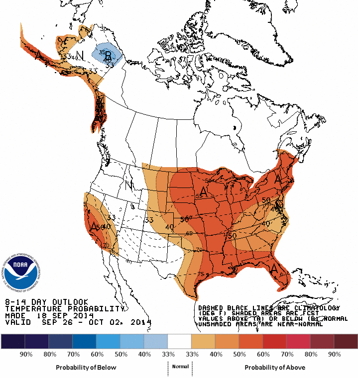
While fall is set to arrive our actual weather may argue to the contrary.  The outlook next week looks to remain quite mild with highs in the middle and upper 70s.  Longer term mid range computer models are also projecting a "Flip" in our over all cooler weather to warmer weather to end the month of September.  The Climate Prediction Center also mirrors this "warmer' outlook into the end of the month in the 8 to 14 day outlook.  


Summer is not ready to say so long quite yet!  Enjoy!

~Meteorologist Chris Vickers

Thursday, August 21, 2014

When It Rains, It Pours!

The first 10 days of August, despite being beautiful, sunny, and pleasant, were also incredibly dry. 
Due to an 'Omega Block', wet, humid air was kept out of our area, while dry, comfortable air was consistently filtered in. 

The blocking pattern is formed when a high pressure system is trapped between two lows, having the appearance of the Greek letter Omega. 

An Omega Blocking Pattern; Image courtsey theweatherprediction.com

Anything under the High pressure's 'bubble' stays warm and dry.
In the first 10 days of August, less than one tenth of an inch of rain fell in Toledo, bringing seasonal rainfall totals to a +2.5" deficit since June 1st.

Then, it started to rain. 

In one single event, on August 11th, the Toledo area received 2.04" of rainfall. Surrounding communities racked up totals in the 4-6" range, and Detroit experience road closures and major delays due to flooding. 

Image from I-75 looking towards I-96 in Detroit; Image courtesy MDOT/Twitter

 Now, more than a week later, it hasn't stopped raining. 
Totals for the month of August range from 1.18" in Adrian, MI, 2.47" in the Toledo area, and 2.66" for Findlay. Near normal totals, with rainfall amounts squeezed into a 10 day period, rather than over the course of 20 days.

While Toledo's (and southern parts of Lucas County's) totals are now above average, some areas still fall below normal levels. 

Month to Date Departure From Normal: August, Image Courtesy Advanced Hydrologic Prediction Service
Yellow areas on the map represent locations with rainfall totals between 0-1" below average. 
Areas in blues and greens are above. 
Purples and pinks are way above.

This could all change in the upcoming week with rainfall, in the form of both light scattered showers and heavy downpours, likely every day into the weekend. So far, totals range drastically across the area:

48-hour Rainfall totals as of 8/21/14
That range will continue, while fluctuating from location to location, to hold steady with scattered shower activity. 

Friday brings the greatest chance for showers. The Omega Blocking pattern is over. THIS is what real summer feels like. 

Friday, August 1, 2014

July: Month in Review

Gotta love the power of email.. and the kindness of coworkers! 
Asked to share their opinion about this July, I received an array of answers from my fellow WTOLers. 

Some were expected:


Comfortable!
Uncharacteristic
delightful
Awesome.

Some were filled with disappointment: 

Lackluster
Lame

Some were confused-- wait, was it REALLY July?

Bogus
WEIRD
OCTOBER

And some were downright creative:

Sandy.   I think it’s the best month to find somewhere where there is sand.


Facebook delivered as well:


One thing's for sure, this was an odd month.


July was a month of disappointment for some, and joy for others. Which is why I love the weather!
It's all relative. Based on personal preference and individual comfort (or tolerance!) levels.

Forgetting opinion for the moment, here's how the month stacked up against the record books:

July 2014 ties for the 3rd coolest July for Toledo ever.


With an average monthly temperature (including daily highs and lows) of 68.9°, July 2014 is only warmer than July 1891 (68.0°) and July 1965 (68.5°). July 2014 ties July 2009 for third place.

Our hottest July day was Tuesday, the 22nd, when the mercury read 91°. Our coolest overnight low was reported at 48° on the 31st.


There was a total of 0.83” of rain for the month, a 2.40” departure from normal!

64% of the month’s total rainfall occurred during one single event on July 23rd.


Overall, it was a dry and extremely mild month.