Severe Weather Myth: An Overpass is a safe place to hide from a tornado.
A famous video (click HERE to view) from the early 90s is largely to blame for this myth. The theory is that if you’re driving along the highway and find yourself in the direct path of a tornado, the best place to hide is under an overpass. Well it turns out that is actually one of the worst places to be. The bridge funnels the air currents and acts like a wind tunnel, actually increasing the wind speeds!
In the video a film crew, along with a family, hide under the girders for protection. Since this clip has been released others have attempted the same protective course of action, only to end in a much more tragic fashion. In the video, although it looks like the tornado went directly overhead, it did not. Barely missing the family/film crew and sparing them from the strongest winds.
So what SHOULD you do if you come up to a tornado in the road? It’s a good question without a single answer. Many times you will be able to simply stop or speed away from the storm. If that is not the case, a next best step is to get out of your car and hide as low as possible in a ditch. Keep in mind you want to avoid a flooded ditch and by exiting your car, you become exposed to flying debris, hail, etc. If this moment happens to you, there is no guidebook, just instincts. But one thing is for sure, don’t use overpasses to try and protect yourself.

Monday, March 26, 2012

Monday, March 19, 2012
Weather Radio Programming Schedule
The StormTrack 11 weather radio programming schedule has just been released. We will be at the following Kroger locations to sell and program weather radios for your specific county.
April 5 -- Jackman and Laskey
April 10 -- Woodville road
April 14 -- Lambertville
April 18 -- Waterville
April 24 -- Port Clinton
April 26 -- Suder Ave
We program the radio so it will only alert you when you specifically are under the gun for severe weather. A weather radio is one of the best tools anyone can have to be alerted any time of anyday. Want more information? Check out this story: http://www.wtol.com/global/Story.asp?s=12681658 (Please ignore the dates at the bottom)
April 5 -- Jackman and Laskey
April 10 -- Woodville road
April 14 -- Lambertville
April 18 -- Waterville
April 24 -- Port Clinton
April 26 -- Suder Ave
We program the radio so it will only alert you when you specifically are under the gun for severe weather. A weather radio is one of the best tools anyone can have to be alerted any time of anyday. Want more information? Check out this story: http://www.wtol.com/global/Story.asp?s=12681658 (Please ignore the dates at the bottom)
Tuesday, March 13, 2012
Does a warm March mean a hot summer?
With 70s and even 80s on the 7-day forecast, the question I have been fielding more and more this week: "If it's this warm now, are we in for a hot summer?"
The answer is, how warm it is right now really doesn't tell us anything about how warm or cold we will be months down the road.
For the past 120 years, records have been kept in Toledo and warmer than average months earlier in the year have shown little to no connection to how warm the rest of the year will be. While the science of meteorology is rapidly advancing we still do not have a great understanding for long term forecasting (3-6months+). There are simply too many factors and our computing powers simply aren't fast enough yet for the complex equations to be run.
This winter was a great example of our long range forecasting downfalls as a meteorology community.


Lets take this a week or two at a time. Enjoy the warmth and sun, mother nature doesn't spoil us too often.
The answer is, how warm it is right now really doesn't tell us anything about how warm or cold we will be months down the road.
For the past 120 years, records have been kept in Toledo and warmer than average months earlier in the year have shown little to no connection to how warm the rest of the year will be. While the science of meteorology is rapidly advancing we still do not have a great understanding for long term forecasting (3-6months+). There are simply too many factors and our computing powers simply aren't fast enough yet for the complex equations to be run.
This winter was a great example of our long range forecasting downfalls as a meteorology community.
Lets take this a week or two at a time. Enjoy the warmth and sun, mother nature doesn't spoil us too often.
Tuesday, March 6, 2012
The Largest March Tornado Outbreak?
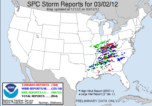
So far the National Weather Service has confirmed 45 tornadoes from Friday’s outbreak; the SPC has 121 filtered tornado reports listed on their website as of March 6th. There is still a question as to the exact number of strong to violent tornadoes but the total will likely end up in the mid 20s. The strongest of these tornadoes is the Henryville, EF4.
While damage surveys are still on-going on reported tornado paths in parts of the Midwest and Deep South, the question has been thrown out: Was this the largest March tornado outbreak in U.S. history?
The answer, yes and no.
In recent memory March 9, 2006 was a significant severe weather day across the central plains. 54 total tornadoes touched down, 22 F2 rating or stronger. It is likely that the March 2nd, 2012 outbreak will top these numbers.

A likely bigger and more wide reaching event occurred on Palm Sunday 1920. The March 28th event spawned 38 significant (F2+) Tornadoes. Since weaker tornadoes were not as well documented in the early 20th century a total tornado count cannot be known. Simply based on the significant tornado count, it is not likely this most recent outbreak will top 1920.
The big question becomes….is there really more severe weather occurring or is out knowledge and awareness increasing to the point of catching every storm?
Over the past few decades storm reports have increased due to an increasing population density and undoubtedly storm chasers. Tornadoes are reported and recorded that simple would not have been seen 10 years ago without these eyes on the storm.
No matter what the exact numbers end up being, this was a devastating tornado outbreak and we wish a speedy recovery for those communities affected.
What the Hail?

No that wasn’t hail you saw Sunday Afternoon. It’s called ‘Graupel’. It forms in very similar ways to hail in a thunderstorm but in a much colder environment.
One of the best things you can learn about the weather is: Warm air rises. I know it didn’t feel warm today, but our high of 36 is balmy compared to single digits just a few thousand feet above our heads. As this ‘warm’ at the surface rises, water droplets form. First creating clouds, then super cooled water droplets. The water droplets stay in a liquid form despite actually being colder than freezing. These super cooled water droplets collide with falling snowflakes and form the graupel you saw today!
So how do you tell the difference between hail and graupel?
-Hail forms during spring and summertime thunderstorms and is very hard. Like an ice cube.
-Graupel typically forms during heavy snow/wintery mixes and easily falls apart in your hand.

Friday, January 13, 2012
A Taste of Winter
The bite of winter has returned, mainly with respect to strong winds and bitter cold wind chills, but light snow and blowing snow did coat the landscape with some snow. Driving in conditions like this still apparently still remain a mystery to some motorist as accidents and spin-outs seemed to be around every corner. That's another issue.
Total snow accumulations for many areas were meek (1-2") with much of that already blown to Youngstown by today's strong winds. (Joking of course) However a few areas did experience a nice winter blast. Parts of Ottawa, Sandusky, Seneca, Erie and Huron counties were blasted with lake effect snow that blanketed the area with 2-4" or more by mid day on Friday. Here is a radar image from 6 AM Friday morning. Notice the lake effect snow band over lake Erie, which moved onshore in a southerly direction. Here is the cool part about this. A lake Huron connection was established in this very specific wind direction orientation which allowed an organized lake effect snow bank with heavier embedded snow squalls to develop off of lake Huron and intensify over lake Erie and then push onshore into areas east of Toledo. Lake effect connections between two separate Great Lakes are generally rare and even more uncommon for them to impact our area.

The result through mid morning on Friday was an accumulation of 2-4" over Erie an Huron counties.

Total snow accumulations for many areas were meek (1-2") with much of that already blown to Youngstown by today's strong winds. (Joking of course) However a few areas did experience a nice winter blast. Parts of Ottawa, Sandusky, Seneca, Erie and Huron counties were blasted with lake effect snow that blanketed the area with 2-4" or more by mid day on Friday. Here is a radar image from 6 AM Friday morning. Notice the lake effect snow band over lake Erie, which moved onshore in a southerly direction. Here is the cool part about this. A lake Huron connection was established in this very specific wind direction orientation which allowed an organized lake effect snow bank with heavier embedded snow squalls to develop off of lake Huron and intensify over lake Erie and then push onshore into areas east of Toledo. Lake effect connections between two separate Great Lakes are generally rare and even more uncommon for them to impact our area.

The result through mid morning on Friday was an accumulation of 2-4" over Erie an Huron counties.

Tuesday, January 10, 2012
Where is the Snow!?
It's been a very mild start to the new year, and to no surprise there is no snow to be found across our area. As we head into the middle of January, that's unusual. The lack of Arctic air into the United States has been a dominant theme. In fact, only 14% of the country has snow cover at this point in the month. (If you follow my previous posts, this is due to a positive phase of the AO or Arctic Oscillation). The result a mild beginning to January:

The warm weather and lack of snow has has some shelving the snow skis and reaching for the golf clubs. Measured snow for Toledo so far this season has been 5.2" which is -7.2" below normal. Toledo is not alone take a look at large cities across the lower Great Lakes that are suffering from huge snowfall deficits so far this season:

The average snowfall for a winter in Toledo is around 37".

The warm weather and lack of snow has has some shelving the snow skis and reaching for the golf clubs. Measured snow for Toledo so far this season has been 5.2" which is -7.2" below normal. Toledo is not alone take a look at large cities across the lower Great Lakes that are suffering from huge snowfall deficits so far this season:

The average snowfall for a winter in Toledo is around 37".
Subscribe to:
Posts (Atom)