Sunday, January 31, 2016

Hello Spring! Two Storms, One ALERT Day

A major spring warm-up with a surge of warmer air through Sunday afternoon.  This will send highs through the middle 50s, which will be more typical of early April!
Storm One
 A major powerhouse storm arriving on the West Coast today will slam California with heavy rain.  Big snow from the Rockies through the southern and northern Plains.  This storm brings us our next Alert Day.
Storm Two

Alert Day: Tuesday.  Much of Tuesday will be chilly, upper 30s and lower 40s.  However, late in the evening Tuesday we will surge into the lower 50s ahead of a powerful cold front.  Heavy rain, possibly in excess of 1" with gusty winds will be expected.  We may even get a rumble of  thunder as the cold front arrives Tuesday night into Wednesday morning. 

7-Day Forecast

~Meteorologist Chris Vickers

Wednesday, January 27, 2016

Major Storm Potential Next Week

Snowfall has been well below normal so far this winter season.  Total snow is 9.4" for the entire season now into the end of January.  

A big storm is expected as a "Panhandle Hook" storm develops over the panhandle of Texas and Oklahoma.  This storm track is notorious, and the most favorable storm position for hammering our area with heavy, crippling snow storms.


However, there is very high agreement among computer models that this storm will go west and north of our area.  This leaves us on the WARM sector of the storm with the threat of heavy rain the most likely outcome.  Rainfall totals from this storm into early next week may bring 1" or more of heavy rain to northwest Ohio and southern Michigan.  Keep up to date on the details, lots can change as this storm is still nearly 7 days away!

Monday, January 25, 2016

Download and Win!


Contest Dates:  Monday 1/25-Sunday 2/7 (Superbowl)

How it works:  Download the WTOL 11 News app and/or the WTOL 11 First Alert Weather App
and you could win
$500! 
Already have the app?  Open it and you can enter too! 
You can register twice, once per app! $500 Winner will be announced
during the 11pm newscast on Superbowl Sunday!


Download the WTOL Weather App: http://shout.lt/bpczK

Download the WTOL News App: http://shout.lt/bpcvJ

Sunday, January 24, 2016

IS THERE ANY SNOW IN THE FORECAST?

SNOWFALL TOTALS
Winter totals in Toledo
Still less than 10"

SNOW IN THE NEXT 48?
Late Wednesday night/
early Thursday morning.

FAST-MOVING CLIPPER
Less than 1" is possible early Thursday.
It will be windy through the day.

WARMER WEEKEND
A warmer weekend is ahead.
It will be windy Saturday.
Rain is likely Sat night and Sunday.

EARLY NEXT WEEK
It should be too warm for snow.
There is a chance of rain Mon/Tue/Wed.

Robert Shiels WTOL    @RobertWTOL

Friday, January 22, 2016

Major Nor'easter Develops

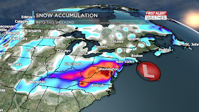
It is a meteorological beauty, but a winter weather nightmare for millions.  A classic Nor'easter continues to take shape and is prepared to unleash Mother Nature's worst on the Mid Atlantic.  Heavy crippling snow along with Blizzard conditions will develop through D.C., Baltimore, Philadelphia and New York City.
Nor'easter Developing -- 9 AM Friday

Winter storm warnings south of the Ohio River -- NO TRAVEL ADVISED south of Cincinnati into Kentucky where 12-18" of snow will be possible. Blizzard conditions into the Mid Atlantic will be worse tonight and into Saturday.  Over 30 million people through the East Coast are under a Blizzard warning into Sunday morning.
Winter Weather Alerts

Total snow accumulations of 12 to 24" with some spots up to 36" of snow will make this an historic winter storm for years to come for many in the Mid Atlantic. 
Snow Accumulation through Saturday Night


Thursday, January 21, 2016

Video Forecast: January 21st, 2016

Historic East Coast Storm -- Update

A potentially historic winter storm is now taking shape. Here is a step by step breakdown of how this storm will develop over the next few days:  
Upper Level Energy develops surface low and storm along the Gulf Coast
Severe storm with the threat of Damaging winds, hail and possible tornadoes across the Gulf Coast this afternoon and evening.
Enhanced Risk Of Severe Storms 
Winter Storm Warnings for heavy snow tonight through the weekend, mainly south of the Ohio River and into the Mid Atlantic.  
Winter Weather Alerts
 Weekend Snow potential through the weekend.
Historic Snow Potential 12-24" of Snow with isolated 30"+ totals
~Meteorologist Chris Vickers

Wednesday, January 20, 2016

Wednesday's Forecast in 3 Images

 Light snow this morning will only last a few hours. This is our only real chance for snow the next few days as a big east coast system will miss us well to the south and east this upcoming weekend. 


Accumulations will be very limited today. Less than 1/2" is expected. 


All national attention will start shifting the next 24 hours to a potentially historic east coast snow storm this upcoming weekend. Some major cities such as DC, Philly and Baltimore could see over 1-2 FEET of snowfall. 


Tuesday, January 19, 2016

East Coast Weekend Snow Threat

 Following up the past 2 winters, this snow season has been a big disappointment for snow lovers. It was not completely unexpected though. See Meteorologist Chris Vickers spot-on predictions here: http://bit.ly/1njgPGp


Right now we only sitting near 50% of normal snowfall in Toledo. And with the weather pattern very active it would seem our chances to climb out of deficit would be high. But not so fast....


A clipper moves through the midwest and southern Great Lakes tonight. Leaving on a small chance for any accumulation locally. Better snow totals will be south of St. Louis along the Ohio River. 


Meanwhile another big winter storm is taking aim at the east coast. This will be the biggest winter storm to date with some locations getting over 1 FOOT of snow. 


While this snow may not fall locally, it could have big travel impacts. According to a study by the US Department of Transportation -- during a major winter storm in 2010 along the east coast over 2300 flight were cancelled: http://1.usa.gov/1ZKNbuG


These flight cancellations can cause a ripple down effect across the entire country. If you have travel plans to airports in the US this weekend, keep this in mind. Plan ahead and be sure to keep a close eye on your flights. 


First Glipse of Lake Erie Ice

Clear skies today gave us a quick glance at the western end of Lake Erie this afternoon, revealing a large amount of ice. The ice is concentrated to the west of the islands with some snow building into the deeper open section of the lake. 


Officially less than 15% of the lake is covered by ice. At this time last year, the lake was well over 80% covered.

Tuesday's Forecast in 3 Images

ALERT: Tuesday morning


Frigid wind chills this morning have led to several school delays. This morning will be the last with wind chills at or below 10 below zero. 


The very cold air has also quickly created ice on Lake Erie. Coverage of ice on the lake has jumped over 12% as of Tuesday morning. This is far behind the pace of last year when the lake was over 80% covered with ice. 


We continue to monitor was is likely going to be a very high level snow event along the east coast. Some of the largest US cities could receiving over 1 foot of snow. The storm will arrive on Friday and last into Saturday. If you have travel plans through east coast airports, plan accordingly. This storm will completely miss Northwest Ohio and southeast Michigan. 


Sunday, January 17, 2016

Monday Forecast in 3 Images


ALERT DAY: Very Cold Monday


Wind chills Monday morning will drop well below zero, as cold as -20°. This would almost certainty lead to school delays if not for most schools being scheduled off for MLK day. 


Some snow showers are likely from lake effect snow off Lake Michigan -- accumulations will be very limited. Likely half an inch or less. 


Now to the big news for later this week. We are tracking a storm system that will develop in the southeast Thursday. This will be a system to watch closely because of it's potential impacts locally. Right now the most likely track for this snow is along the east coast. Dropping the heaviest snow on some of the biggest US cities. A secondary track that is possible is the yellow track below. It is the least likely of the two paths but would have a high impact locally. Stay tuned as we watch this threat evolve over the next few days. If the blue (and more likely) track verifies, our area will end up with little to no snow.


Saturday, January 16, 2016

Saturday's Forecast in 3 Images

After a brief warm-up late this week, we are heading back to some very cold air by the end of this weekend. 


Highs today will be near freezing, but quickly tail off after dark. Some patchy ice is possible as water standing from Friday's rain freezes.

Arctic air really takes hold Sunday with highs in the teens. Lows will be in the single digits several mornings this week. Wind chill values may dip below -10 Monday morning. 


Friday, January 15, 2016

WEEKEND FORECAST

SATURDAY

Windy and colder, snow flurries.
Winds west 10-20 gusting to 25 mph.


 WEEKEND

It will turn colder through the weekend.
Snow showers are possible Sunday
with gusty windy, highs in the teens.

Robert Shiels WTOL    @RobertWTOL

Thursday, January 14, 2016

FRIDAY WEATHER HOUR-BY-HOUR

THAW CONTINUES FRIDAY

Temperatures will be above freezing all day.
Set the snow shovel aside,
grab the umbrella instead.

FIRST THING IN THE MORNING

A dry and mild start to the day.

HIGHS AT THE NOON HOUR

Low/mid 40s at the lunch hour.

RAINY AFTERNOON

It may be mild for January,
but rain at 40 degrees is a COLD rain!
Keep the umbrella handy.

Robert Shiels WTOL    @RobertWTOL


Wednesday, January 13, 2016

Wednesday's Forecast in 3 Images


ALERT: Wednesday Morning


Bitterly cold arctic air is locked in place for today with highs in the teens, wind chills below zero this morning. Icy roads have caused many school delays too. 


We are tracking a fast moving, weak clipper system that will bring light snow near sunset and just after tonight. 


Total accumulation will be less than 1" tonight -- warmer air arrives Thursday and Friday. 


Tuesday, January 12, 2016

BITTERLY COLD OVERNIGHT

OVERNIGHT LOWS

Close to zero degrees Wednesday morning.
Toledo record is 15 below.

WIND CHILL READINGS

Wind chill: -5 to -15 to start the day.

WEDNESDAY HOUR-BY-HOUR

You can expect a slow warming Wednesday
with highs near 20 late in the evening.
Snow showers and a minor
accumulation possible.

Robert Shiels WTOL    @RobertWTOL


Tuesday's Forecast in 3 Images

ALERT DAY: Tuesday

2-3" of snow overnight, combined with strong winds have closed nearly every school in northwest Ohio and southeastern Michigan. (Photo: Tom Hosler)


Strong winds will continue all day -- lead to more blowing/drifting snow and very cold wind chills. 


Heading into tonight temperatures will drop quickly -- eventually falling to the single digits overnight. More blowing and drifting snow is likely. This means more delays and closings for schools are possible Wednesday.