Thursday, August 29, 2013

New Study Names 3 Major Ohio Cities 'Safest from Natural Disasters'

A new study released by property & real-estate giant, Trulia, claims to provide homeowners with the inside scoop on Mother Nature's fury.

Stormy Weather over Put-In-Bay, OH: Summer 2013

Based on information and data collected from the National Oceanic and Atmospheric Administration (NOAA), US Forest Service, and FEMA's National Flood Insurance Program, the study takes into account neighborhood information and a history of weather violence.


The result? A list of the top ten cities least likely to be impacted by flooding, earthquakes, hurricanes, tornadoes or wildfires.

Ohio contains three of the ten cities on that list. 


Here is the list:

1. Syracuse, NY

2. Cleveland, OH

3. Akron, OH

4. Buffalo, NY

5. Bethesda-Rockville-Frederick, MD

6. Dayton, OH

7. Allentown, PA

8. Chicago, IL

9. Denver, CO

10. Warren-Troy-Farmington Hills, MI


Does this mean, meteorologically speaking, there is a smaller risk of death or destruction in Ohio based on geographical location? Perhaps. But a study looking at the broad risk of multiple weather phenomenon without a focus on the severity of the existing climatological data seems to lack, in my book. 

Tornadoes are on the list of 'least risk' for this study, however in 1974, a tornado in Xenia, OH caused 32 fatalities as a part of a 12-tornado outbreak in a less than 24-hour period of time. 

Xenia is located just 15 miles East of Dayton, OH. 


Xenia, OH, 1974 tornado outbreak


The Xenia tornado was rated an F-5, and the damage done was estimated at $100 Million (in 1974, not adjusted for inflation).

Case in point: The study shows no research considering the impact of winter weather, blizzards or Lake Effect snow. So since many of these cities on the list are located in the Great Lakes region, researchers should be careful to say that the weather here doesn't have a big impact.

http://www.cbsnews.com/8334-505145_162-57599608/top-10-safest-u.s-cities-from-natural-disasters/


Wednesday, August 28, 2013

8 Years Later: Katrina Aftermath

On this date, 8 years ago, Hurricane Katrina slammed into the Gulf Coast, tearing a path through cities and homes, killing 1,577 in the state of Louisiana (NOAA). 1,833 total fatalities were reported.

Hurricane Katrina, 2005

When the storm raged inland from the Atlantic, it reached Category 5 Hurricane strength, with winds up to 174mph. The central pressure of the storm dropped to an astonishing 902mb, as it developed over the course of 8 days in late August.

No storm since the 2005 disaster has come close in comparison to Hurricane Katrina. At roughly $81 BILLION in damages, Katrina broke down the region's levees and flood walls, forcing authorities and the Corps of Engineers to build a new 100-year flood protection system. The storm's surge reached a height of 28ft at its peak and the name 'Katrina' was retired by the World Meteorological Organization in 2005.


Devastation and flooding in the wake of Hurricane Katrina
Eight years later, Karina's scars still exist. The X mark can be seen on some homes, placed there by rescue workers who searched flooded neighborhoods for casualties. According to relief workers in the area today, over 6,000 home owners are still in need of a rebuild-- many without the funds to do so (St. Bernard Project).

Tuesday, August 27, 2013

2 Amazing Satellite Images

Algae in Lake Erie has been very common the past few decades due to run-off from farms and ditches in northern Ohio/Southern Michigan. While not as vibrant as previous years, the algae and sediments in the lake are visible from space. This image was taken over the weekend. Notice the darker shades of blue on the deeper eastern basin of Lake Erie. 
 

Another, even more amazing shot is of the wildfire that is raging in Yellowstone National Park. The smoke from this fire is being driven north by winds in the atmosphere. It is rare that a wildfire is so easily seen from space.  

Wednesday, August 21, 2013

From Below to Above Average August


 Up until this week, there have only been 5 days in the 80s this August. For less than 30% of the month, temperatures have been at or above average, leaving everyone wondering 'what happened to summer?'

Nothing to worry about, folks.
Summer is here.

Take a look at Wednesday's Almanac:


Almanac: Wednesday, August 21st, 2013
The page shows just the second above average day for the month of August, occurring yesterday, 8/20, with temperatures reaching the middle 80s for the first time since July.

Now that we've broken the mild pattern, however, what can be expected for the rest of the summer season?

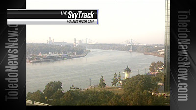
SkyTrack Maumee River Cam, Wednesday Morning 8/21/13
80s will be likely through the rest of this week, and with a blocking High pattern setting up for next week, 90s look possible as well. 

A warm week ahead-- temps will remain above average.
So, even as the kids head back to school, and the summer season winds down, Mother Nature still has a few tricks up her sleeve, and it looks as though we're about to make up for all of those 60s and 70s earlier this year.

Tuesday, August 20, 2013

Full Moon -- Tonight!

A bright full moon is expected to light up the night after sunset this evening.  Remember to check this out!  One of the benefits of waking up in the middle of the night, I get to appreciate the brilliant shine of a full moon on a late summer night when I am out the door for work at 2 AM.  Better yet, the full moon tonight will happen on a clear and comfortable night.


Each full moon has a nickname, they are often based on ancient folklore.  This month is the "Full Sturgeon Moon".  Many attribute this full moon in August to local fishing tribes and their pursuit of the sturgeon, a large fish in the Great Lakes.  This month was a very popular month for fishing the sturgeon in Lake Erie and the other Great Lakes.  A few tribes also knew it as the Full Red Moon because, as the moon rises, it can appear reddish through the common sultry haze during the late summer month of August.  This haze can be a result of dust, pollen, smoke from far distant wildfires or any other particles suspended in the atmosphere. 


The moon will rise at 7:56 PM this evening, with best viewing between 8 PM and 10 PM tonight.  If you catch good pictures send them to me on Twitter: @ChrisWTOL or Facebook: Meteorologist Chris Vickers

Sunday, August 18, 2013

Back-to-School Forecast


The week of back to school weather is historically summer-like. On average, temperatures in late August range from 81-83°. This 'normal' has only been achieved 2 times out of the past 6 years.

2008
Back-to-School High Temp: 94°!
Monthly Average: 83.5°

2009
Back-to-School High Temp: 84°
Monthly Average: 81.0°

2010
Back-to-School High Temp: 90°
Monthly Average: 84.8°

2011
Back-to-School High Temp: 89°
Monthly Average: 82.8°

2012
Back-to-School High Temp: 91°
Monthly Average: 82.6°

2013
Back-to-School High Temp: FORECAST: 88°
Monthly Average: 77° (so far)


2009 was a very comfortable year for students, but 2008 was a scorcher! This year will fall somewhere in between the two. With high temperatures forecast in the middle and upper 80s all week, the students will need to be in shorts and tshirts to stay cool.

Hopefully the schools keep the air conditioning running on high until temps level off, and the Fall season takes over.

Check out toledonewsnow.com for a full list of Back-to-School dates.

Saturday, August 17, 2013

A Mild August-- So far

Think back...

When is the last time we reached 80° in Toledo?

6 days ago.
On August 11th, the high temperature recorded at the Toledo Express Airport was 82°.

Now, for the more challenging question. When's the last time we reached 85° or higher?

25 days ago.
On July 23rd, the high temperature was 85°, and since then, we haven't been that warm!


While you may be enjoying these milder temperatures and a less than sticky August, it is atypical. No summer season is complete without a handful of scorching hot days and a few weeks worth of 80s. This week, we will return to 'normal' with highs back in the 80s.

7-Day Forecast Beginning August 17th
Before the pattern change takes place, we will have experienced only 5 days so far this month at or above 80°. 5 out of 16 days comes to less than a 30% occurrence of truly summer-like heat. 


So, like it or not, it's about time to say goodbye to the 70s for a while, and embrace the season with 80s coming back to claim the month of August.

Tuesday, August 13, 2013

Summer Heat, Where Have You Gone?

The extreme heat that scorched the area much of last summer may have eased a bit from memory, but this year we have a clear reminder how much the weather can and does vary from season to season and year to year.  Last summer was miserable, a severe drought and record heat with 4 days above 100 degrees and a sizzling 32 days at or above 90 degrees.  Essentially, a full one third of the summer was 90 degrees or warmer.  This summer is quite the opposite.  Here is how this summer compares up to August 13th:


Not only has this August recorded zero days at 90 degrees or warmer, the average temperature is an astonishing 69.1 degrees which is -3.2 degrees below normal.  Long term weather upper level atmospheric flow remains persistent with a vast Great Lakes trough revolving around the semi-permanent Hudson Bay upper level low that has dominated much of the summer. 


Here is the monthly breakdown for the average temperature for each of the three summer months through this point in August:

June: 69.1° (-0.4°)
July: 72.2 (-1.3°)
August: 69.1° (-3.6°)

It does appear that more of a zonal (west to east) atmospheric flow may arrive toward the middle of next week which will mean some warmer weather going into the final third of August.  Despite that we are essentially guaranteed to end the month, and thus the summer statistically below average in terms of temperature.  It is still possible we could reach 90 degrees once or twice more this year but time is running out.  Here is the last 90 degree day and date the past three years:

2012 - August 31st
2011- September 3rd
2010 - September 23rd

Oh, and naturally the next question ALWAYS is "since this was a cool summer, will it be a colder winter?" Answer: NO.  (More on that in a future blog post!)